You have to believe the utter shock on my face when I found out that not all the Channel Islands are part of the National Park unit. I mean, there are only 8, they really can’t just take all 8? Then, I learned that two of them are used by the Navy as bases. Trust me, there will be a lot of disappointments incoming on this post, but that comes later. I knew of the Channel Islands from a long time ago, when I bought the National Park guidebook published by National Geography. Back when… I think there might only be 59 national parks? Anyway, it is mostly politics, we are up to 63, but it wasn’t like new parks were designated from completely new places; most of the time it is just a name change, and most of these parks were almost always part of the National Park Service (NPS). Anyway, the Channel Islands were in my sight because my boss from graduate school did his graduate school in Santa Barbara, which is a stone’s throw away from the Channel Islands, and he would talk about the camping trips on these islands. I do not remember the details, but they sounded fun, kind of like on a desert island, yet you are almost back at home. With my eye set on hiking the Trans-Catalina, and only to find that Santa Catalina IS NOT part of the national park, I had no choice but to plan an additional trip. I really have to check off this national park while I’m in the Channel Islands (Catalina Island), and I would like to check off at least one national park a year.
I would have assumed ferries are running between these islands. I mean, WHY NOT. Maybe to control the human population, I’m not sure, but the only way to get to Channel Islands by public transport is to get to Ventura (or Oxnard), which is an hour northwest of LA. I looked for some ways to get here via public transport, and I did not trust Amtrak enough to take it. So, the logistics were to take the metro to the airport, ride on a jet, rent a car to drive up and park the car at the ferry terminal while I’m off venturing on one single island. It sounds like a lot of effort, resources, and pollution for a tiny trip, and I have nothing to say against that. Life’s short?
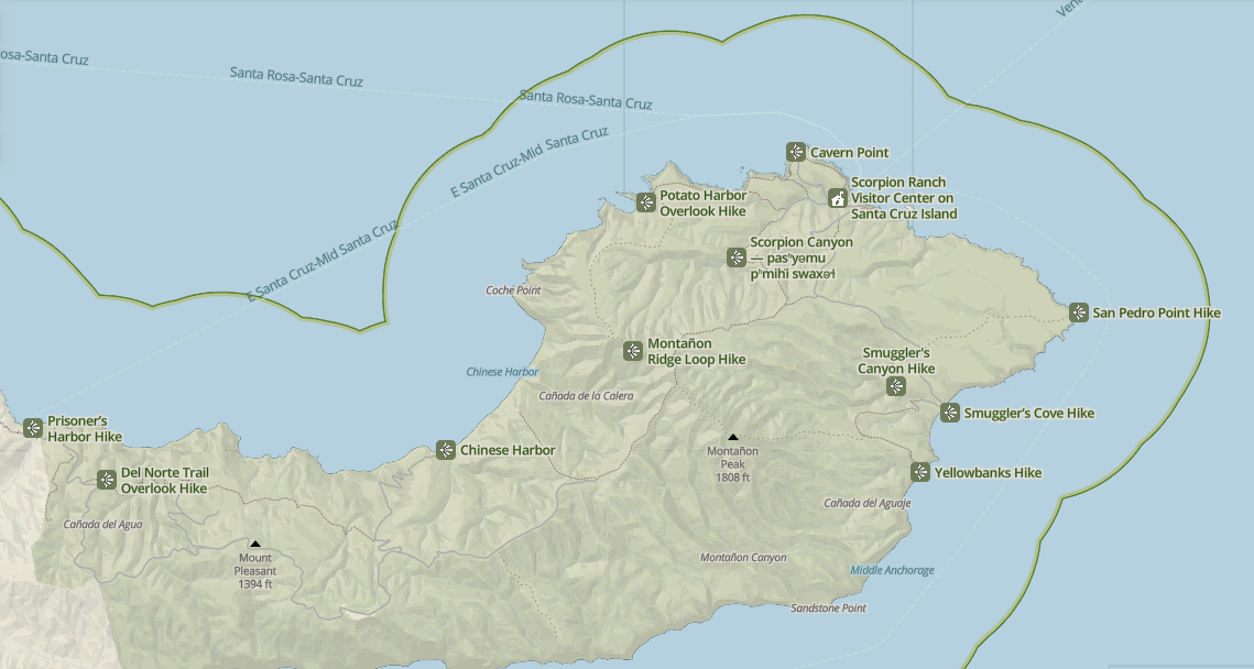
So, part of the fun is to figure out which island to go to, and for how long. While the NPS governs these islands, they do not provide any transport. Actually, now that I’m thinking of it, I do not believe NPS provides water transport, ever. Anyway, I booked my tickets in advance from Island Packers Cruises, they do not run often, and they do not go to every island every day. For example, in November 2024 on the weekends, there are only two boat rides to Santa Cruz/ limuw [1] in the morning, and two in the evening. Do not miss any boat rides, because I do not think any private taxi services could get you back on the mainland, and I’m assuming most/all of these islands are self-sufficient. Of the five islands here, I chose to visit Santa Cruz and dock at Scorpion Cove because it seems like I could do the most hiking here. There is a different Santa Cruz dock at Prisoner’s Harbor, and that package comes with a ride into a giant Sea Cave (if tides allow). The islands all have their own specialties, and depending on the activities (sea kayak is very popular, snorkeling too, or camping), you might choose a different island. I will say that I missed out on taking a picture at “Inspiration Point” on Anacapa Island.
Due to the cold shallow nutrient-rich ocean, and the islands have their own evolution pathways, there are a ton of marine mammals in the sea, and endemic plants and wildlife on the islands. Both of these are a huge draw to tourists, and the captains of the cruises are eager to spot them. The boat ride ought to have taken around 1 hour each way (depending how which island), but with frequent stops, this can really drag on. This is to serve as a reminder that while the boarding time is pretty accurate, the dock time is not. The only Visitor Center at Ventura is literally the next building over from the ferry terminal, but they open only from 0800 to 1700. The only feasible way to visit an island and the visitor center is to go to the visitor center first and board a later boat ride. I now know that there is no way the boat will arrive before 1700 no matter what time they departed the Islands, and plan accordingly.
After flying into LAX and driving an hour Northwest, I arrived in a slightly smoked-out Camarillo to stay the night. There was recently a forest fire in the nearby forest, but the wind has all but blown it away. All that was left were huge signs telling people not to go back to their homes in the mountains, and the smell of burnt wood. I did some quick shopping at a nearby Walmart and ordered In-n-Out to go. Stocked up on food and supplies before heading to any of the Channel Islands, besides the snack bar on board the boat, there are no food or even drink services on the islands. There are a ton of affordable motels just outside of Ventura, so choose your own poison. No reason to stay in Ventura proper as the ferry terminal is not walkable from Ventura.
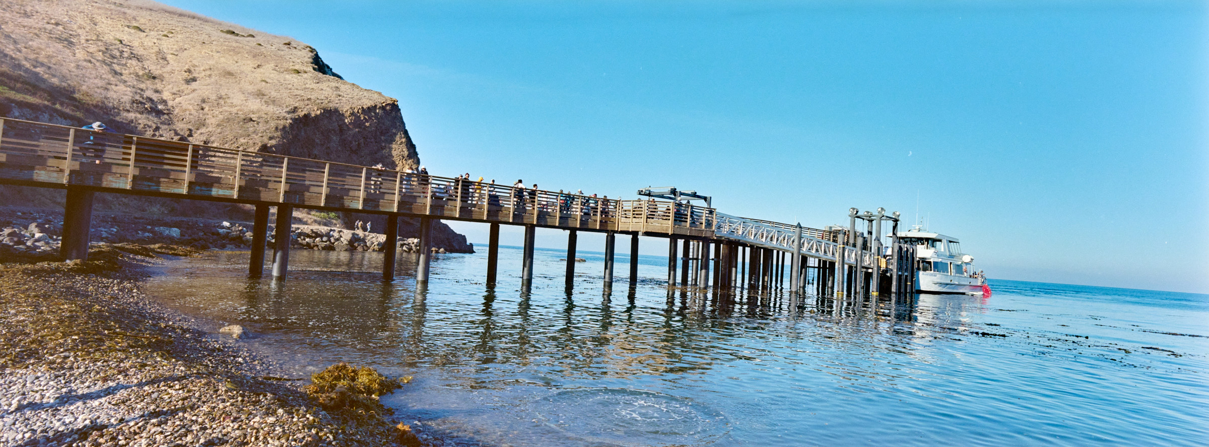
Speaking of that, we received a warning to arrive early for our 0800 boat ride from Ventura to Scorpion Anchorage due to some events, so I got there an hour early, and I was one of the very first. There is a large parking lot at the ferry terminal, and some street parking just outside; I don’t think parking is an issue for anyone leaving on the first boats, but it could be for everyone else as it filled up pretty fast. The LA weather is amazing in November; 10C (50F) before the sun, and 20C (75F) in the sun. Lots of locals are decked out in down jackets, which is useful to block the wind chill while sitting out on the deck as the cruise is sprinting across the ocean. I retrieved physical tickets from the counter, which is weird because they have already given me e-tickets. Then, just wait for the boat call and board the boat. They have very strict rules here regarding fuel canisters and “checked’ bags, so arrive early and follow crew instructions. Unlike Catalina Island, these are run by younger outdoorsy people, so the vibe is very different.
The ocean is calm, and I sat on the 2nd floor overlooking the north. The morning crew just wanted to get over to the island and probably back for lunch, but they did the usual leisure boat marine life sightseeing items. Yes, these leisure cruises are not ferries, and they will try to entertain the passengers during the crossing by telling you some facts about local geography, and race to the next water sprouts. I saw a few humpback whales’ water sprouts and them barely surfacing. There were also a lot of dolphins swimming alongside the boat, something that dolphins seemed to love to do in general. It is a good alternative to chartering a boat just to see marine life, and most people here are daytrippers and love this extra bonus. On the other hand, though, I can see the weary faces of people who are experiencing seasickness or just want to get to the destination quickly. Even though I plan to only hike on this trip, many people have paid for kayaks and snorkeling gear, so getting there earlier means more time to do what they love.
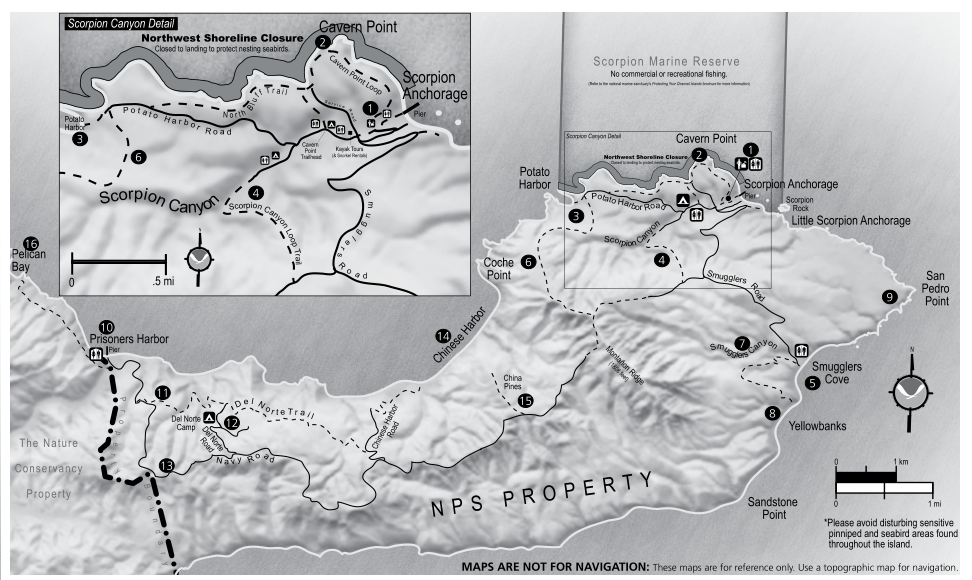
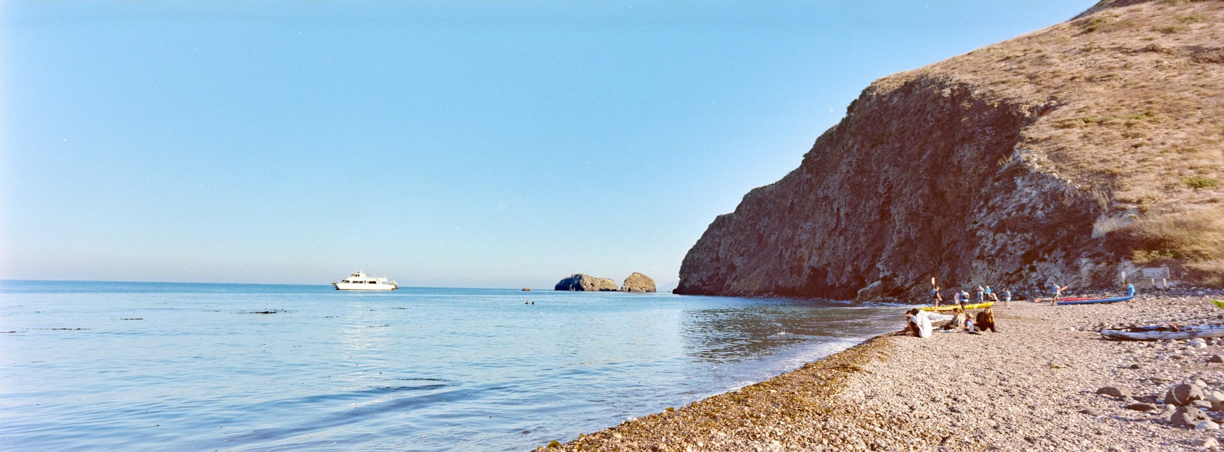
After a few wildlife encounters, we landed at Scorpion Anchorage after 90 minutes. There is a mandatory briefing by the park ranger while we are on the pier, who happens to be the only park ranger I met. The rest of the park seemed unmanned. Everyone broke off to do their own things while I was slightly disoriented and had to look up what to do on the maps. I guess I’ll plan my own hiking trip if there were nobody to suggest an itinerary. The only accessible water points for daytripper are in the campsite at Scorpion Anchorage, which also has a few pit toilets that could use some care. I loaded my tiny daypack, and went on a trip by doing a clockwise loop starting from Scorpion Anchorage down Smuggler’s Road to Smuggler’s Cove (~4miles); back to the campsite via Scorpion Canyon Loop trail (~4.5 miles); before hitting the north coast at Cavern Point and follow the coastline back to Scorpion Anchorage (~1.5 miles). I didn’t actually count the miles before leaving, but it ended up being close to 11 miles. It is a leisurely pace for me, considering I have a little less than 6 hours to do it. With a little bit of foresight. I ought to have been able to get to Potato Harbor, which is supposed to have good views of the coast as well. Some other off-trails near the very western portion of Santa Cruz Island could probably be done on a day trip; otherwise, most of the other trails would probably have to be done either on a multi-day backpack trip or from Prisoners Harbor, the other docking site. Even though Santa Cruz is the largest of all the eight Channel Islands, only the western quarter of the Island belongs to NPS; while the rest mostly closed to the public, belongs to Nature Conservancy. Just a detail, the short story was that the last major owner of the island did not want to sell it to the federal government and instead transferred it to the Nature Conservancy, thus what we see on maps today.
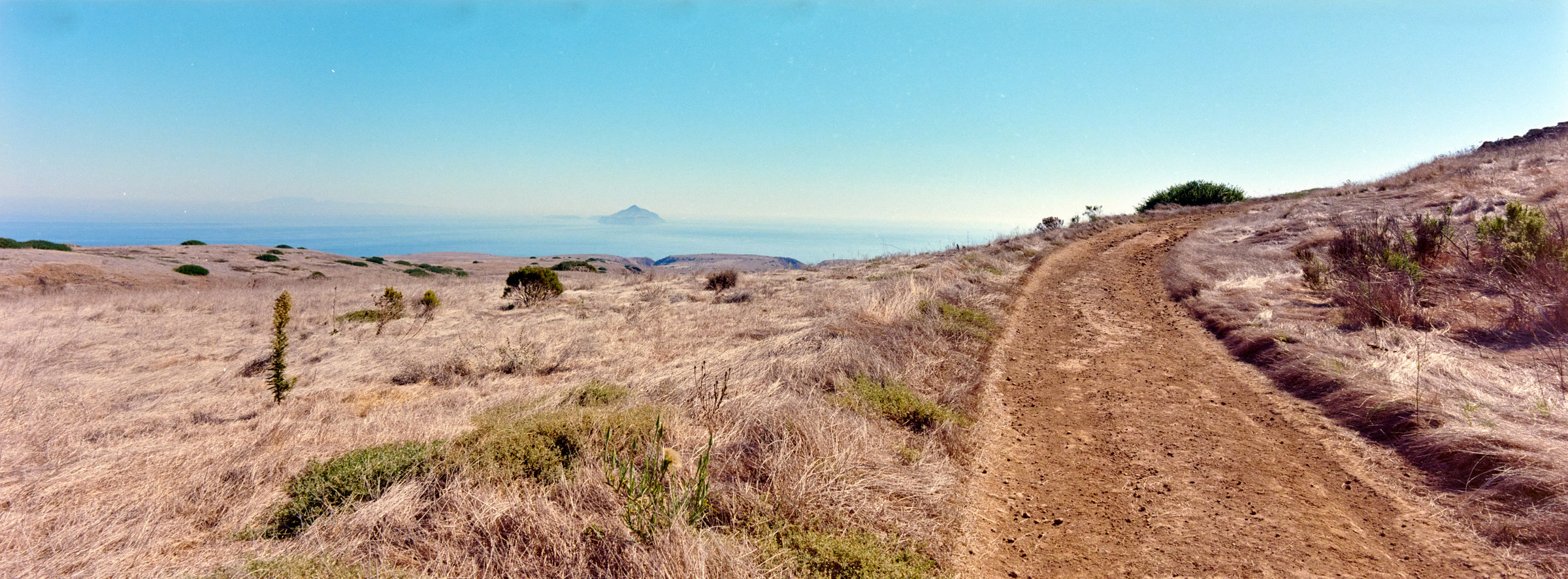
I did a quick walk-through of the Historic Ranch, including the unmanned NPS Visitor Center, at Scorpion Ranch. It was alright, looks like any random parts left on the side of a country road. With that, I left whatever little civilization left, and hiked up the hill on Smugglers Road. The trail is very well maintained for some offroad vehicles, and the gradient is not too bad. I was mostly in the shade as Scorpion Anchorage is in a canyon, and the sun is not high up enough, so it was very nice to hike. That ended quickly though, once I got to the top of the hill, and mostly walking on the flat plateau until the drop down to Smugglers Cove a few miles later. I don’t know what I was imagining but I did not expect to be hiking on a desert island. So the good thing is, the views are great, I could see miles out in any direction. I could make out the huge mountains on mainland California/L.A., and the huge Anacapa Island just east of us. Well, actually it is one of the smallest islands, but huge compared to the very boring flat ocean. There are some trees here and there on the plateau, but it is mostly just very low shrubs and cacti just like a desert. Great for photography down the Scorpion Anchorage where I was at, and the Scorpion Rocks on the little viewpoint trail. There is a nice yacht down in the emerald pool, and I kind of regret not spending some time in the gorgeous water. I’m stuck up here among the brown earth and brown bushes.
I know most free maps should not be used for navigation, but they are generally good enough, especially for well-established trails. However, maps might not get updated as frequently as what is de facto, the real trails. After the really nice viewpoint on the Scorpion Cove, I lost the coast while walking through the plateau, and saw an official “shortcut” through Delpines Grove. I was not going to skip out a shortcut, a place called Delpines, a possible grove on a desert island, and I did not want to go over the hill. And I was rewarded, in the middle of the plateau, a grove of trees! There must be some endemic plants here, and there are huge signs warning anyone from camping here, probably to protect these rare plants. I continued on without much delay, as I would like to finish the trails before my ship left me. Around mile 2.5, I got to the fork where I’ll come back later – this point out it is going to be a “quick” out and back to Smugglers Cove. I fasten my pace, partly because it is getting easy because the trail is going downhill down to the cove, mostly because I’m really excited to eat my packed lunch. The trails past the fork are in much rougher conditions compared to previously, as they are wide but not meant for vehicles anymore, but still in very good conditions, just have to avoid kicking some huge rocks. I raced down one large half-mile major descent at got to the trailhead at mile 4.5.
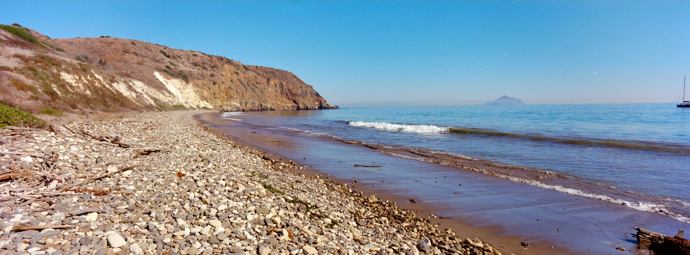
There is already a party of two pairs of couples eating lunch, and another farther-son duo eating lunch while fishing. Besides these few people, there are a few yachts in the cove, but I saw no movement while I was there. I plop down on the huge picnic table underneath a huge shade and enjoy the view of the small rolling waves crashing on shore with Anacapa Island, still in the distance. There is a sliver of sandy beach between the ocean and the otherwise pebble rocky shore. Personally, I much prefer the pebble rocks, but I know it is blasphemy for most. The Double Double Animal Style I bought last night still tastes great, especially with the Starbucks nitro cold brew, though I just realized that I’ve got ones with sugar and creamer. Oh well, it’s not like I can get a replacement in the next few hours. Boo-hoo. After the very scenic lunch break, I decided to hop over to check out the Smugger’s Ranch. I know, it makes no sense, but who works as a smuggler and still has a ranch? I’m assuming that the ranch is named after Smugglers Cove, but nobody is here to correct me. The Ranch is cool with beautiful flowering bushes and even a citrus tree(?).
There are some unmarked trails (according to NPS anyway) towards San Pedro Point and Yellowbanks Vista and even a larger loop of what I would like to do, but for safety’s sake (as well as the lack of planning and topo map), I retracted the 2.5 miles back to the split, but this time, my tummy is full, the weather is getting warmer (with the wind behind my back) and I’m going 700ft uphill, so it felt much slower and longer. I’m passing a lot more people now going towards the cove, which is curious as I wonder what they were doing earlier, but they could have just done the reverse course of what I’m doing. Once I hit the split, the rough road became a nicer road, before reverting to a single-track walking trail at mile 7.5 as I hit the Scorpion Canyon – this change is also marked as dash lines on the map. The good news is, since it is a canyon, it is beautiful with lots of trees and shade, something I’ve not seen in hours. However, the trail is much steeper here, made of loose gravel causing it to be slightly slippery. It would have been a better idea to come up this way, but for some reason, the NPS map recommended clockwise. Maybe most people prefer not to hike up steep hills, but at least I don’t slip going down? The canyons resembled ridges into the hills, which reminded me of the dramatic ridges seen on the very popular helicopter ride somewhere in Hawaii. Much less cool here, and much less green.
After the steep slope down, it was flat land. Even though I knew there were campsites ahead, I couldn’t really see until I stumbled into a group of Boy Scouts who were just leaving camp. There are water fountains here, the same kind of sprouts in the morning, and also a lot of bees (or possibly wasps) just chilling at the tap waiting for humans to open the tap so they get rained on. I assumed they just wanted to chill in the water or drink the water, but they only wanted to stick their head into the tap for a reason. The other campers kind of told me about this phenomenon but also mentioned that these bees were harmless, and I kind of agreed. Foxes also frequent these campsites, as they are unafraid of humans and know that most people do not hide their food well enough. I saw a fox in the morning slowly walking through the tents to try to find something but did not see any foxes here. Guess animals are generally more active at dawn and dusk, and it is closer to 14:00 now. By the time I loop back to where I got water in the morning, it is about 90 minutes before my boat leaves. The unfortunate thing about these free maps is that it can be hard to piece together the information that I need. I probably could make it to Potato Harbor, even with 90 minutes left, but I was not going to risk it without knowing the real distance back. Instead, I chose the much safer route that’s 2 miles long and headed one last uphill towards Cavern Point.
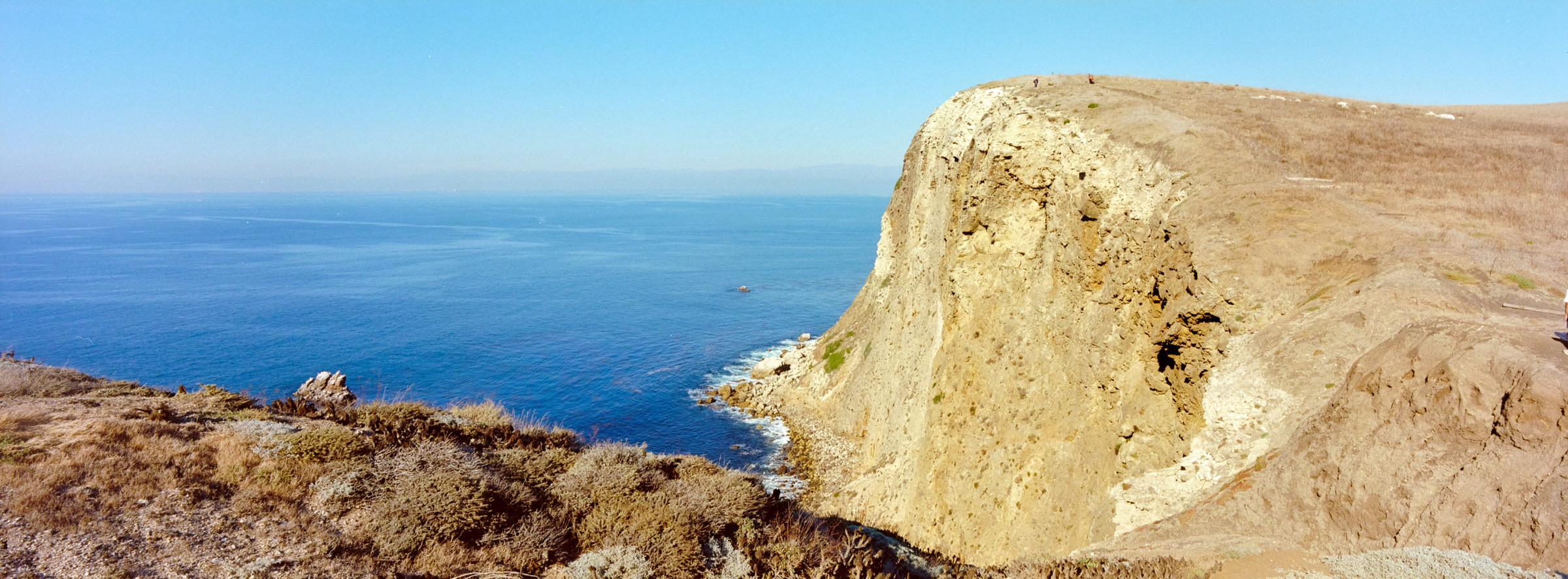
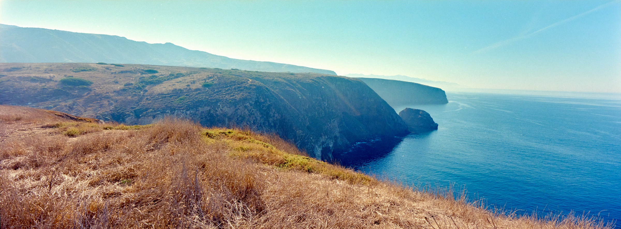
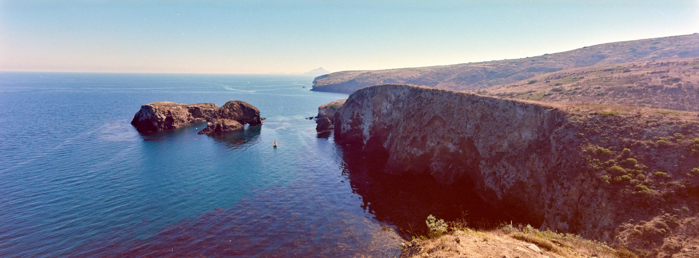
There are many more activities here. I know that there are at least two boatloads of people and additional campers from previous stays. Most people did not plan to stray too far from the anchorage and probably only made it here. As a result, it is much livelier here, with people from all walks of life. I actually if this might be a first hike for many here – unlike the Pacific Northwest, where hiking is a way of life. I’m still impressed meeting PNWers who insist they hate hiking, and avoid the trails, but could and would complete a 10-mile trail with nothing but their phones, getting out of the trails to grab their pint in the afternoon. PNWers are just built differently. Cavern Point is extremely stunning as I’m 200 feet up a cliff, and I can see the rugged edges of the island extend for miles in the western direction. It is a slight shame that the sun is also in the same direction and causes a backlit scene, but that’s life. The eastern direction is not half shabby, and I get to see Anacapa Island again, this time with Santa Cruz in the foreground. It is rather impressive.
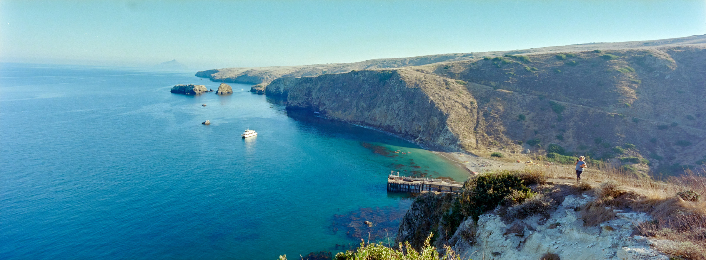
And then, as I was expecting to spend at least another 30 minutes walking to the pier (and arrive at least 15 minutes before my 1530 boat ride), I managed to circle back to Scorpion Anchorage. I was definitely kicking myself for not heading towards Potato Harbor for the longer loop, but hindsight is 20/20. (Actually wouldn’t it be 0/0, or are we allowing mistakes even with hindsight?) I hung out by the very sad and unmanned visitor center for a little while, before heading to the beach for a quick view of the beach. Lots of kayaks are back, but there are still children running around with some minimal adult supervision. I did not bother to even touch the water, and it seemed some of the very wet children were cold. I always assume the waters around LA are warm, but I think I’m mixing that up with Hawaii. There are lots of seaweeds washed up to the shore, and with that, lots of weird flying insects and even some smell. I could also hear the ferry incoming – it is so boring and quiet out here without the wind, so a boat heading our way is extremely obvious. I waited on the pier in line with lots of other tired tourists. Once the few people left the boat – these are all campers for the night – we were quickly loaded onto a different boat from this morning.
I booked for the earlier boat back (by 30 minutes) so I could get to the visitor center before they closed at 1700. Theoretically, that’s plenty of time. However, as mentioned previously, this was a leisure boat, and although I don’t think anyone requested it, our captain decided that looking for whales would be the most important thing for the passengers. I could literally see that we were more than halfway towards Ventura when the captains noticed a sprout behind us and decided to do a U-turn to turn back to Santa Cruz. It seems like these humpback whales are shy, or just not interested in us, and would take a breath every 15 minutes, rather than just show themselves. So, our captain (and many passengers) waited patiently for the whales to surface, and slowly got disappointed, only for the captain to give up and started heading towards Ventura again. And as you can imagine, the whales decided to surface and sprout even further back, and the wild goose hunt continued. We must have done at least 2 more circlings before a huge feeding frenzy occurred close to sunset at around 1700. Supposedly, the whales, dolphins, and seabirds all surrounded a school of fish, which makes for easy picking. This is actually really impressive to watch, and we are literally surrounded by hundreds of dolphins swimming around us (and I assume eating too). Huge pelicans and other seabirds will also dive to try to catch anything. But no whales sighting this time – possibly much deeper than us? Anyway, after this incredible spectacle, our captain was satisfied, and we were finally making a beeline towards the harbor. I felt bad for anyone who had seasickness. By the time we got to the harbor, it was way past sunset, the NPS visitor center was closed, and all that was left was for me to find dinner.
It is hard to describe Channel Islands National Park. Many of the mountain peaks are clearly visible from L.A., and I would have assumed it is somewhere most locals would have been. Besides the tiny resort of Avalon on Catalina Island (which is not part of the park), many people simply choose not to visit? Then again, it is a similar story to how the islands were conquered – they were always there, but few people bothered to venture out to visit. To be fair, the Los Angeles metropolitan area is very close to many other great parks, so many that I wonder if I ought to make L.A. a base camp while I slowly check places off. With my single visit, I got a quick taste of what the Channel Islands provide – a quick desert island escape from the hustling and bustling. I could see myself coming back, way later in life, to check out Inspiration Point, or one of the incredible sea caves. Trying to check off all 5 islands (Santa Barbara has been closed since Covid) might be a tall order for an out-of-towner, especially with the lack of interisland transport. Though the hike was fun and the vistas are gorgeous, Southern California also boasts incredible sights that could rival this. The one card up the sleeve of Channel Islands is the marine life and the ease of renting a kayak and snorkeling gear, and I totally agree. Looking at the turquoise and emerald water all day, I was wondering if I’d made the wrong choice, that I was up here in the brown grass and short cactus. With that said, I’m glad I’ve got one national park checked in 2024. But…. will this be the only one, even though it is already late November? Will there be a last-minute surprise?

Ranked: ****
Issue 94. Volume 14. Chapter 6.
Visited: November 9, 2024
Address: 1901 Spinnaker Drive, Ventura CA
Website: https://www.nps.gov/chis/index.htm
[1] limuw is the Chumash word for Santa Cruz Island, meaning “in the ocean”. The Spanish named the island Santa Crus (Sacred Cross) after a legend of a priests’s staff left on the island that was returned to the priest by a Chumash Indian. https://www.nps.gov/places/000/santa-cruz-island-limuw.htm
1 thought on “Channel Islands National Park”