I knew that once I was on trail, I would be less worried about it. Not that I’m concerned about too much when I’m traveling, but there are still things my subconscious mind is keeping track of. There were a few errands to do before I got on the trail. The first thing was to check into the hotel I was staying the night before at Long Beach. One of the things that are highly incompatible between being a tourist and being a backpacker is the ease of traveling. Sure, the weight and size of luggage do matter when I’m a tourist, but that’s mostly to avoid getting surcharged by the airline, rather than having to figure out how to bring everything along. Similarly, in this case here, I’m transitioning from a tourist into a backpacker, at this very moment. My backpack with everything I brought along needs to be rearranged and is sitting in the trunk of the rental car (to prevent any break-ins that are kind of infamous in LA now? Or maybe that’s just the media). Which means, I have a rental car that I must return, but if I do that, how would I get to my final destination? Lots of minute details and annoying to deal with. So, my final solution was to grab a quick dinner, drop my bags at the hotel, return the car at Long Beach Airport, and finally take an Uber back to the hotel. Not very complicated logistically, but it is still a chore and an extra expense if I’ve stuck being as either a tourist or a backpacker. Such is life.
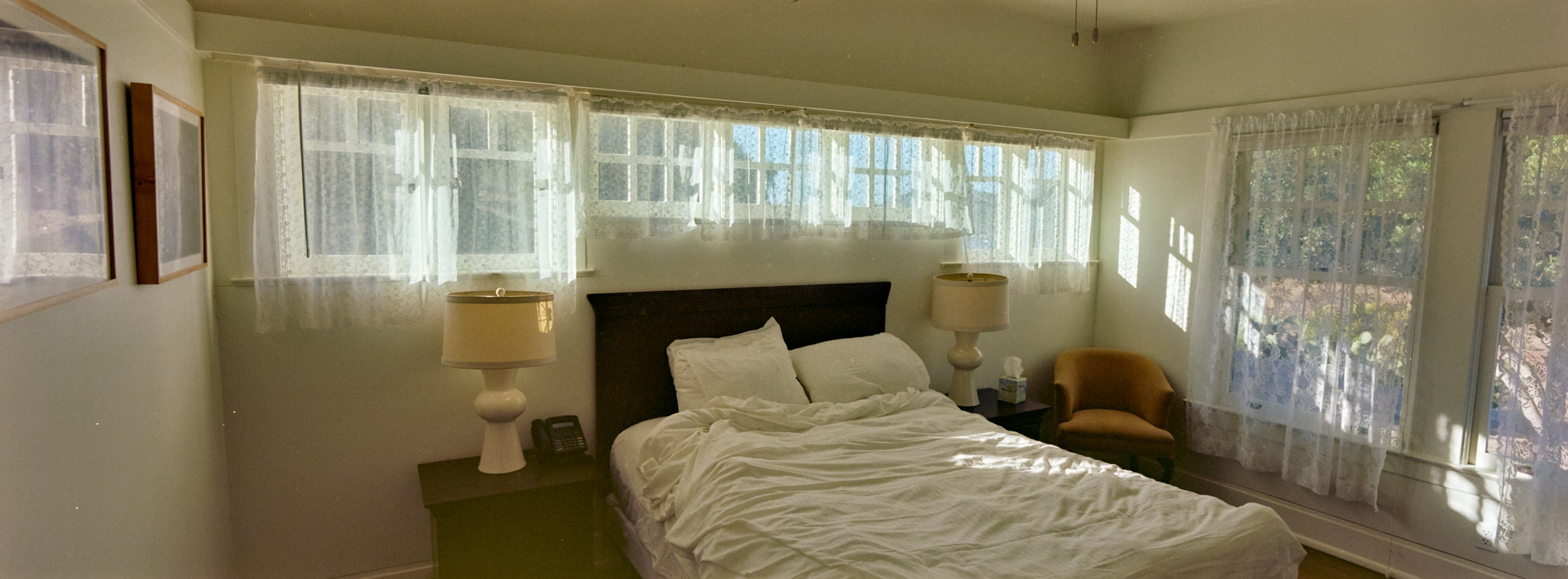
The drive to Long Beach was long but not very exciting. The sun sets over the Pacific Ocean, but I cannot make out Catalina Island today. As far as I could tell, I’m in the very industrial area of Long Beach, with lots of big cranes and containers, so it came as a surprise that I would take an exit off the highway and end up in front of a huge Hilton right next to the Los Angeles River. Being a solo traveler means I have to park at the 5-minute-parking-zone, check in and exchange pleasantries before unloading my car to dump my stuff up in the room, and finally move my car away, all in as little time as possible. The hotel is nice enough but it is one of that glamorous hotels where everything is not free and people dress their best to hang out in the lobby. I am extremely out of place with my outdoor clothing and a huge backpack, but per the internet, this is the best hotel to stay if I need to walk over to the ferry terminal. For some reason, Hilton also left a crib in my room – I don’t think I was expecting but it is kind of them to think that.
I sprinted off to the airport. I’m not in any real rush, but I rather be in the room and doing other chores, and time is always of the essence. I left the car with the attendant and walked away with no baggage. It is very nice for a change, not having to lug things around, which will not be the experience I have for most of this trip. Long Beach Airport is tiny and doing a facelift, and they have this older Art Deco Terminal that looks lovely but not in use. I got my Uber and headed back the way I just came. My driver did a triple take because he was extremely confused by the lack of bags coming from the airport – I tried to explain my grand plan but I’m not sure if he understood or cared. Once I got back to the hotel, I had to rearrange my bags into the main bag and a day bag assuming that I had to separate my gas tank and electronics. Then it was time for bed. Now planning for sleep is easy but planning when to wake up is hard. The ticket clearly states that I have to be at the terminal 45 minutes before the boat departs at 0600 on Monday morning. Just to be safe, I opted to wake up at 0400, so I have time to take another shower, and working backward, that meant I had to sleep ASAP.
I did wake up at the first alarm, cleaned up as planned, and walked over to the ferry terminal. It was chilly but bearable, and the main thing was to get used to having 50lbs on the shoulder, which most backpackers can tell you, is difficult the first few days. I was proud that I did not flip over in the next few blocks to the ferry terminal, but I did wonder if this is doable for the rest of the Trans-Catalina Trail (TCT). I decided to take the scenic route along the bay, even though there was nothing to see except for darkness and streetlights, and I ended up on the wrong side of the ferry terminal as the doors were still unlocked from this side. Had to do the walk of shame and go around the huge building and enter through the front side, as expected, an hour before my boat departure. Guess what – even the counters are not open yet. I chilled in one of the seats and waited for something to happen. People slowly trickled in, but everyone looked like they were not tourists – most likely employees going back to Avalon to work on Monday. Many skipped the warm lobby and formed a line just outside the ferry, which was parked at the pier already. When the ticket counter opened, they happily told me that as I had the etickets, and could just proceed to the boat 15 minutes before departure. THANKS? The boat was mostly empty when we boarded it, and this boat did not even have a luggage hold. We just put our big stuff at the back, and there is not a need to separate items from the bag. I took a seat, ate my breakfast, and slept through the ride. Unlike the Channel Islands ferry, these are boring ferry services with no announcements on marine life, which I think most people are satisfied with.
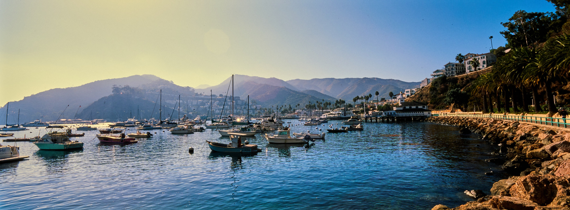
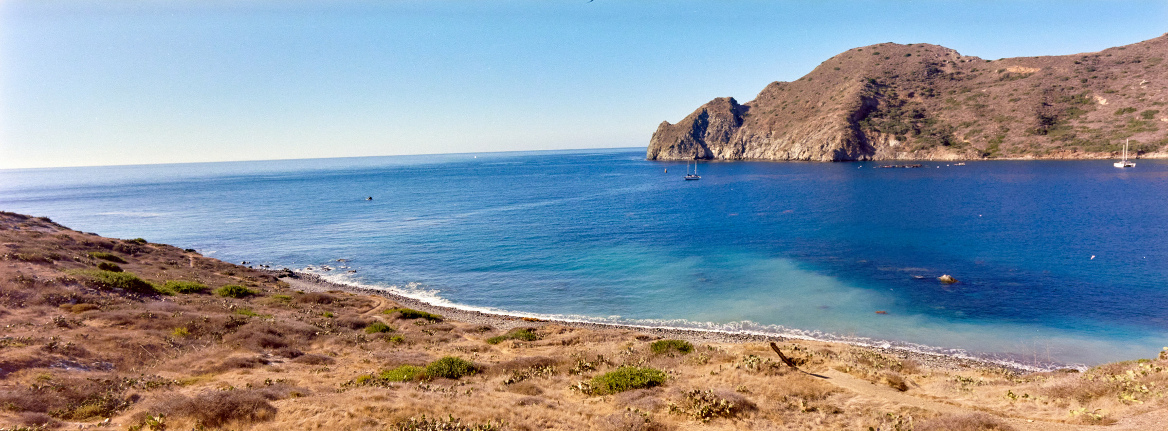
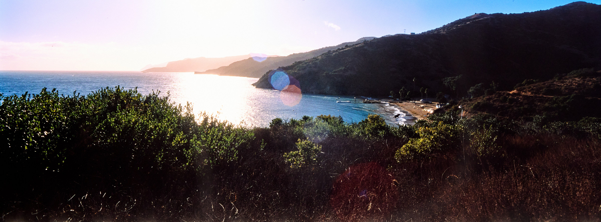
When I woke up, we were about to dock at Avalon on Catalina Island. The biggest attraction is the Casino – yes, a huge white circular building by the coastline. I was wondering about going there to gamble, but I also wasn’t sure what is the etiquette, can people just walk in with money? Everyone was courteous leaving the boat, I doubt anyone is extremely happy to go to work, and I don’t think I saw anyone else with a backpack. Well, that changed once I left the boat, and I saw a few backpackers who planned to ride the boat that I just left. I was so excited to talk to them about their experience or to be part of the cool club, but I had more errands to run and most of them seemed to avert their eyes. The first thing was to find a laundromat, and then figure out where to get a cup of coffee. The town felt dead at 0800, but there were people in both locations. I managed to figure out how to cramp everything down to the 80-liter backpack (thank you Tetris for the years of practice) and enjoyed my coffee on the little benches overlooking the sandy coast. Avalon is weird – looks like a Mediterranean coastal town, the way buildings are mostly in the canyon and not very tall, and extremely scenic. The quick observations I had – the roads were narrow, there were mostly golf carts, and residents seemed to be made up mostly of Latinos, which anecdotally, I heard way more Spanish than English. A huge difference from Los Angeles just over there. Extremely quiet on a Monday, supposedly this is the low season even though the weather is great – maybe too cold for locals. Since I do not plan to spend any additional time in Avalon, the only town/major civilization on Catalina Island, I decided to walk the extra half mile towards the Casino building, knowing that I will not have a chance to visit it again. The building is very beautiful and ornate, with a huge juxtaposition of the emerald water and the cliff in the background. I did not attempt to go into the building, instead, checked out the few dive stores on the base of the building, and enjoyed the view of Avalon from here.
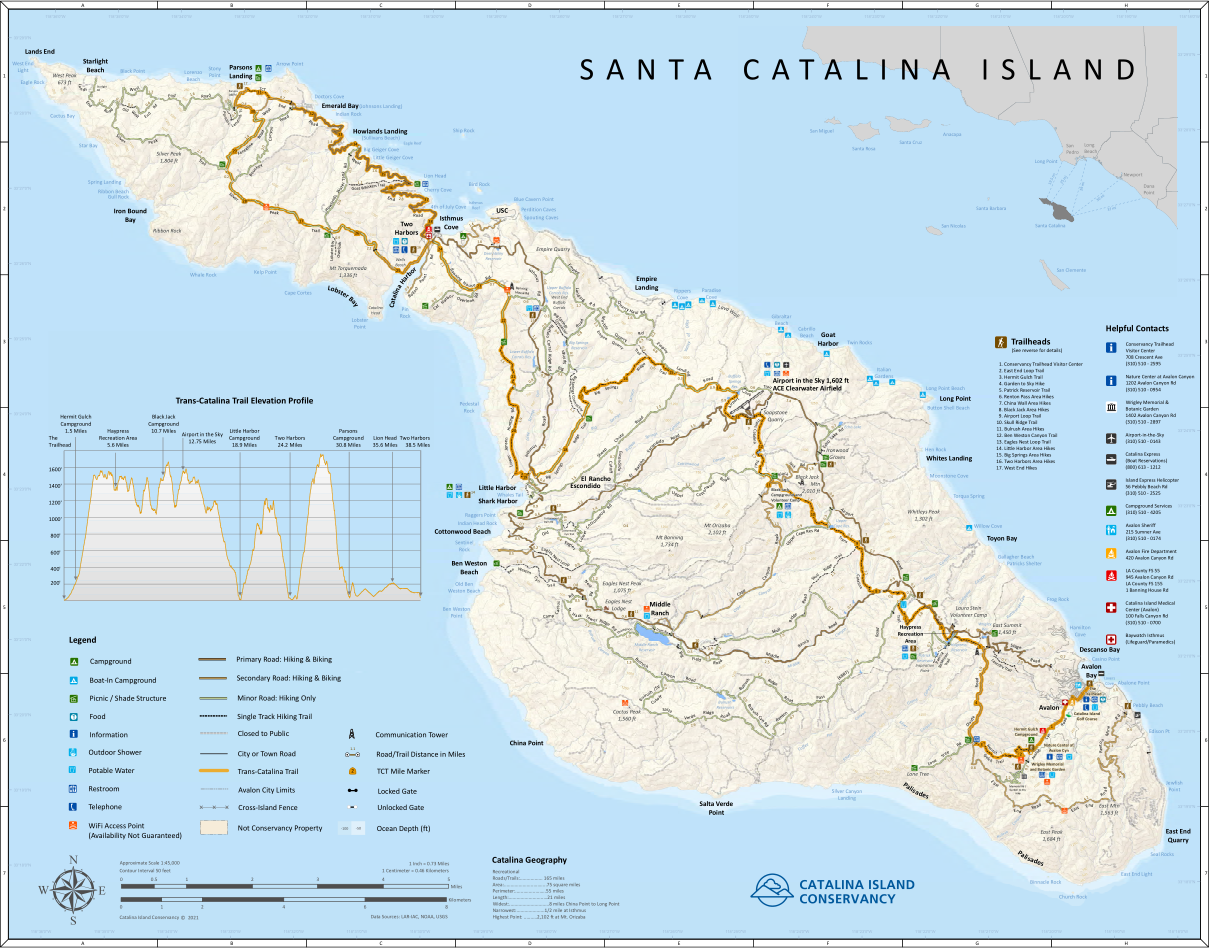
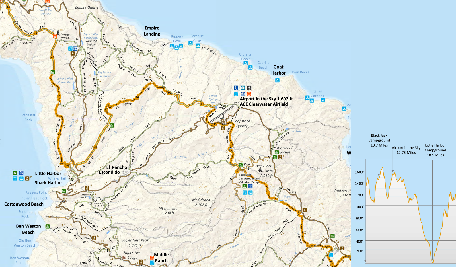
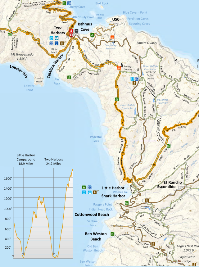
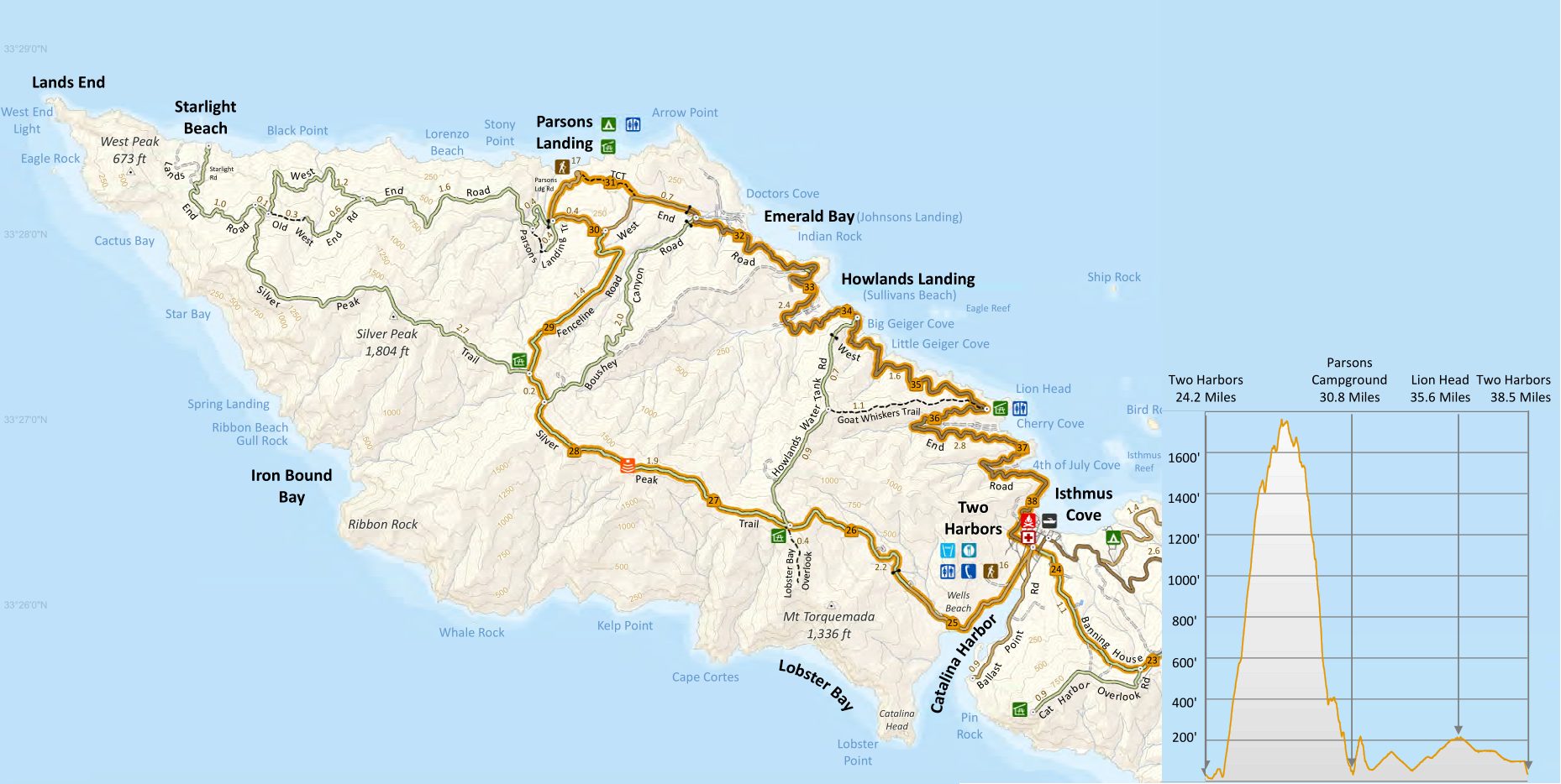
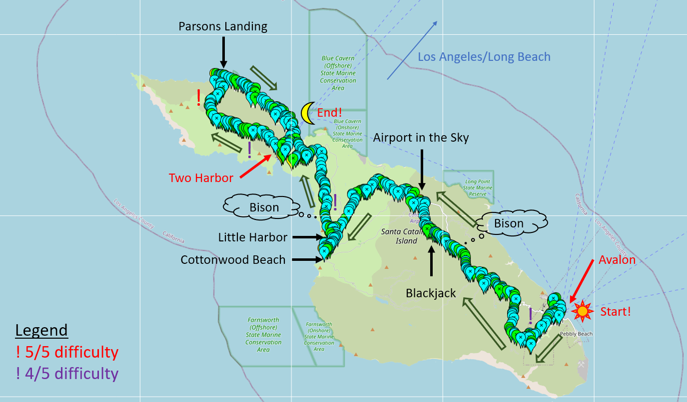
To begin the TCT, I have one more thing to do. I headed towards the visitor center, which told me to go to the cool-looking modern building next to it – the Catalina Conservancy. There, I met a very enthusiastic ranger who told me the dos (and a few of the don’ts), and places I should check out on the trail, and sold me the last piece of equipment I needed – a huge trail map. I have a digital version already, but it probably did not hurt to have a paper version too, and it is so much nicer to stare at than on a 3-inch phone. Also, great souvenir. The one thing the ranger was unable to help me was to get to the trailhead. He kind of told me it was over there by the Hermit Gulch campsite and showed me a hand-drawn map with cartoons, which was even more confusing. There are no signs to say “this is the beginning” or “this way to the first campsite!”, so I decided to start from the fake pier with the visitor center, called that my starting point, and used Google Maps to figure out where exactly is the rest of the TCT. Official start time, 11/11/24 at 1000. With that, all the errands have been completed, all belts are tightened down, and my only objectives on the TCT are to get to the next lodging location and to eat lots of food. For day 1, I’ve to hike from Avalon to Black Jack campground, at mile 10.7 on the TCT. Sounds like fun!
*****
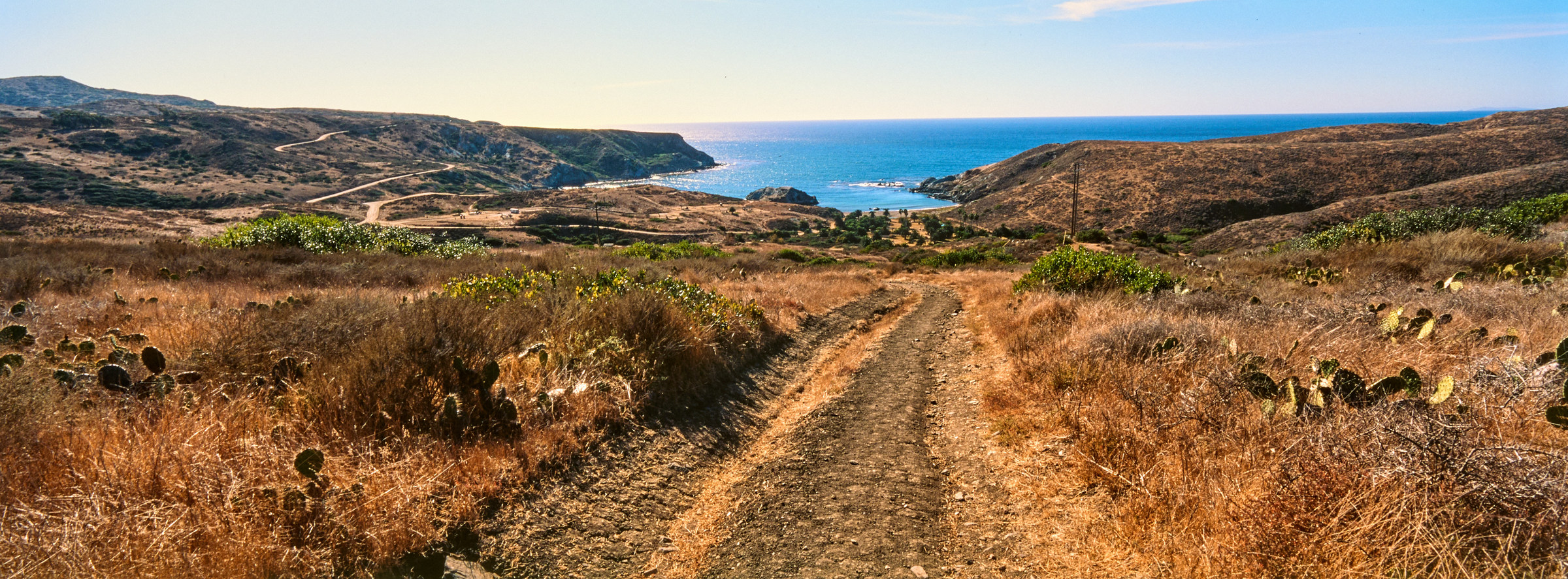
Day 1: Avalon to Black Jack
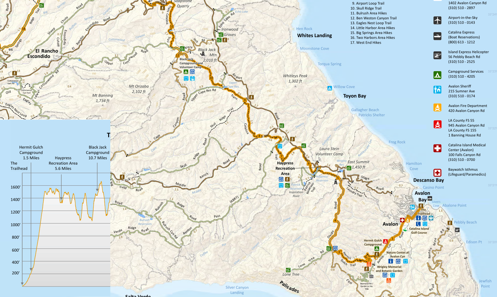
The first mile of the TCT is nice, as I got to wander through the tiny houses of Avalon, where residents live, then walk through the back of this valley/town, where they place all the city parks, ballpark, and even a golf course. It is extremely deserted of people already, though still feels like part of the town. I did see the only ground squirrel on my entire trip here, an endemic island squirrel, because there are not many trees to climb. It is here where the road intersects Hermit Gulch campsite, where I asked for further directions and was told that I would find it by the last campsite. There is also a detour possible here, to go through Wigley Memorial via the Garden to Sky route and connect to the TCT later, but I did not check my newly bought map and just followed the official route. The new ranger was right, there was a huge sign near the final campsite that pointed to “Trail”, so I’m officially not lost! Then, the climb begins. Supposedly, this climb out of Avalon is the hardest part of the trail. I did not realize how much we were climbing for a while. The backpack might be heavy, but it hadn’t hit my dumb brain yet, and the hillside is providing huge shade. It was hiking in amazing weather, so even though it was uphill, it was not bad. The view into the valley is decent, there are plenty of shrubby trees, but the canopy is not thick enough, so it is still obvious I’m on a desert island. I spotted a huge clear-cut trail on the next canyon over, and I was wondering what that was used for. It looked nicer to hike up that straight slope than the narrow switchbacks I’m on. After a mile of climb, I realized I was sweating nonstop and decided to take a quick break to drink some water. It is close to lunchtime as well and decided to take the lunch break at a shelter, clearly marked on my paper map at mile 3. Speaking of mileage, I’ll guesstimate where I’m at based on the official TCT – party for the ease of this essay, but mostly because I don’t remember that well. I could hear hikers in front of me, and behind me, but besides a silhouette or two, it was just me and my thoughts.
It did not take me too long to get up to mile 3 and up around 1600 feet. It was around 1130, so perfect lunchtime when I got to the circular shelter. I’m not sure why, but the Conservancy would only build shelters with unfilled roofs. I’m assuming that means that it is easier to maintain, however, that also kind of defeats the purpose of a shelter… Let’s see, wind, rain, and sun go through the roof, and these pesty ravens just stand on them and quack at me. I’m not surprised if they would launch grenades too! Regardless, I sat my gear down, took out my bagel, and squeezed peanut butter all over it. Might not be elegant, but it was delicious, and I got to top them off with some cookies too! Three college-age guys came up while I was wrapping up, they looked beat and mentioned to each other about a loop. There might be a bottle of water shared among the three of them? I gave them a heads-up, but soon caught up and even overtook them. Hopefully, they made it back to Avalon safely, no idea where they were going, but they did not seem to be heading to the side trail towards a place named “Lone Tree”. My version of the paper map did not indicate all the scenic spots, but an earlier copy I found on the internet did, and it was only much later I realized that that would have been a good side detour, but I wasn’t willing to jeopardize the first day of my hike.
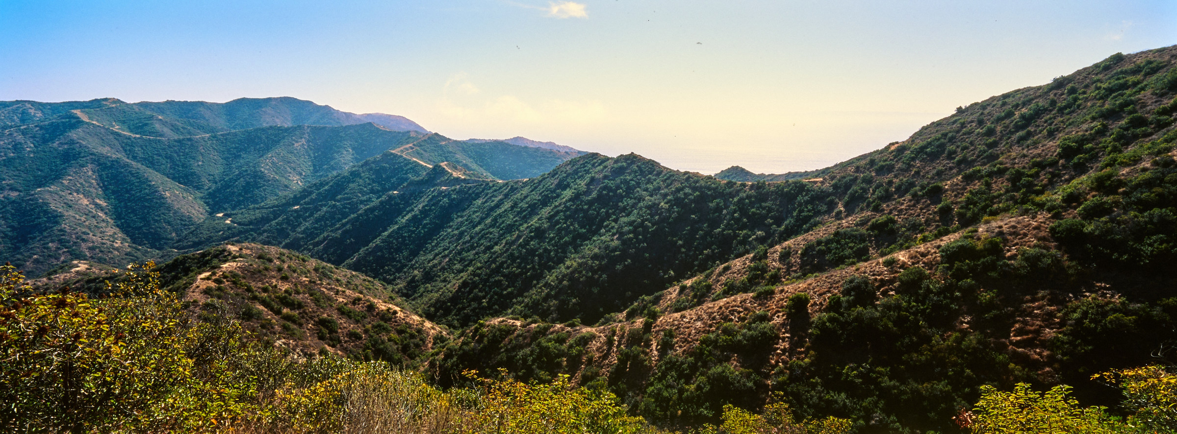
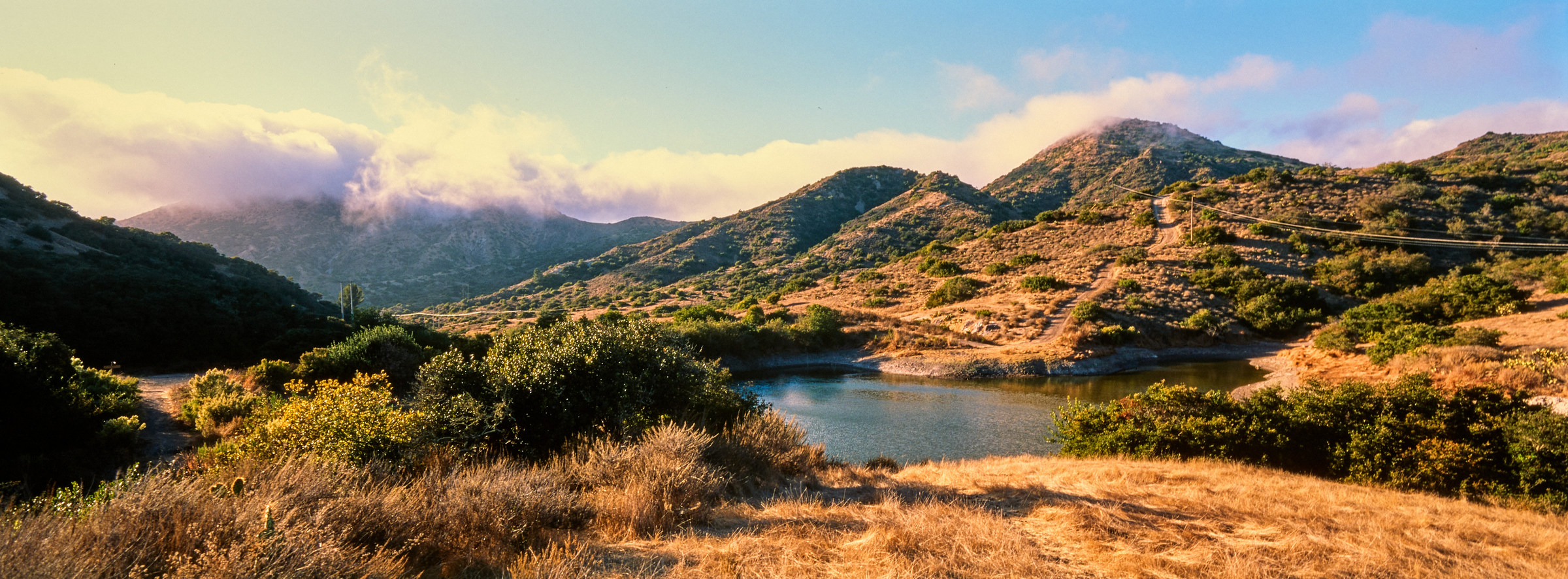
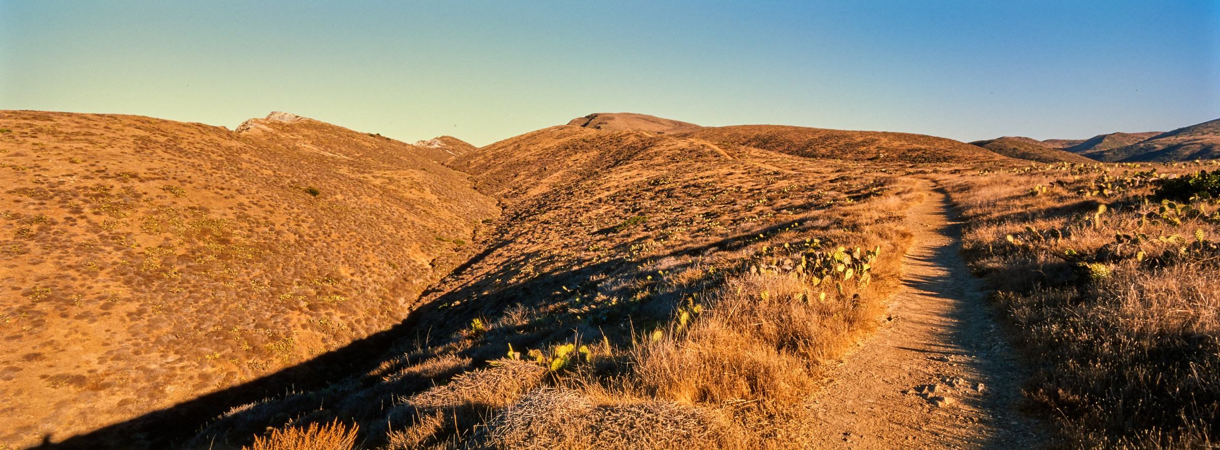
The next few miles were much nicer, as I was walking along the ridge of the mountain – however, it was also not the prettiest hike. It was around this time when I slightly regretted coming here. The view is mostly of rather flat plateau filled with low shrubs and cacti. Even though the island is tiny, I’m in such a flat area and far away from the ledges that I cannot see much of it. Avalon is now barely a memory, and the trail, though nice, is basically a road for four-wheel drive. In fact, I saw a few jeeps and vans pass close by once the trail connected to the main road artery at mile 5. One of the guides even told the captive audience to give me a round of applause! That’s kind of bizarre – I don’t even think people on the PCT get that kind of welcome. The weather definitely warmed up, and I was trying my dang hardest to drink water. It wasn’t to prevent dehydration, more that I did not want to carry this much water, and I knew there are two more water points before I got to my campsite, which also had potable water. Carrying 3 liters of water up that hill now sounded kind of dumb, but it shall remain as a practice run. I noticed on the map that there are a few reservoirs around this area, but the first one – Wigley Reservoir, was completely dry. The second was the Haypress Reservoir, which looks kind of a like very sad pond but at least the water tap works, and I could get potable water, and probably one of the cleanest pit bathrooms I’ve ever seen. This is also the area that I must cross through a fence gate, into the “truly wild”, where the bison roam. During the colder season, the only real danger is probably getting gored by these bison. Nobody knew why the bison were brought onto the island, but according to Wikipedia, it happened around the 1920s, and they seemed to be happy grazing grass here. Even though bison are not native, the Conservancy decide to keep around 150 bison on the island, and as a result, their shit is everywhere. And sure enough, with the Jeeps stopping in the distance (everything is very easy to spot since there is so little canopy), I could also spot a few brown things, and on closer inspection, was reminded that I was hanging out in bison’s territory. I continued my merry way and stumbled onto the second water tap in the middle of the trail. Literally, in the middle of a field not near any other human things, just a single random water tap. Such an odd sight that it was funny.
I did a quick time check at mile 7.5, where the random water tap is. It has been 4 hours since I started, and I will have 3 hours of daylight left to finish the next 3.5 miles to get to the campsite. Sounded easy enough! At this point, I’m dipping in and out of the valley. Not much elevation gain, but there is also not much to see. I’ve lost the road, the sea, Avalon, and even the mountain ridge. The only thing to focus on was to get down a canyon, only to climb back out and repeat. The lazy sun is beating on me, but it is also getting cooler, and the sun is waiting to go down the horizon. The wind picked up much more here compared to earlier, but it wasn’t ridiculous. It was around mile 9 when I saw a huge cloud covering the mountain peak. Had to do some quick orienteering, and noticed the huge tower on top of the peak is Black Jack Mountain, and I’m supposed to stay just below that. At least on my copy of the map, it says the road to go up is locked, and that makes my life slightly easier with fewer things to check off. However, I also noticed that not only the campsite is not as close as I was hoping, but there is also a huge valley I must drop down before climbing up again. And the huge cloud over where my campsite will be is worrying me a little. I did notice there was at least one hiker behind me, seeing them at least a mile or two behind me when I was on top of a peak. I was hoping to cross paths with other hikers, but the bare handful was either going in the opposite direction or just day hikers.
As I was just muttering complaints to myself, I noticed a huge bison standing not too far from the trail. On the one hand, I would love to be able to get to the campsite and set up my tent; but on the other way better hand, I do not want to die. So, there is nothing to do at this point but to chill and pray that the bison would go further away from the trail. This bison is just going to town on the grass, and so munching so dang slowly. I was even wondering if they get stung by the cactus, but they probably do not care. I sat my bag down, took out the multipack of Tony’s Chocolate that I’d brought (This post is sponsored!), and ate as well. It is a little past 1500 and I only have a bit more than a mile to go, so I’m not exact crunch on time, even if the sun sets at 1700. However, I doubt I’ll be cooking in the dark, so eating a snack so close to dinner might be a bad decision. But is eating chocolate ever a bad decision? Speaking of snacks, after around 20 minutes, the bison had moved far enough from the trail that I was comfortable to use the trail again. The bison knew I was there, but could care less. I sped past as fast as I could and then did not stop for the rest of the hike. There was a bit more climb, and I inched closer to the clouds and the cell tower. I did spot a white building among the canopy, but it felt much further than I hiked. In the end, I made it, 11.11 miles on day 1 in 6 hours, and I had around an hour to set up the tent.
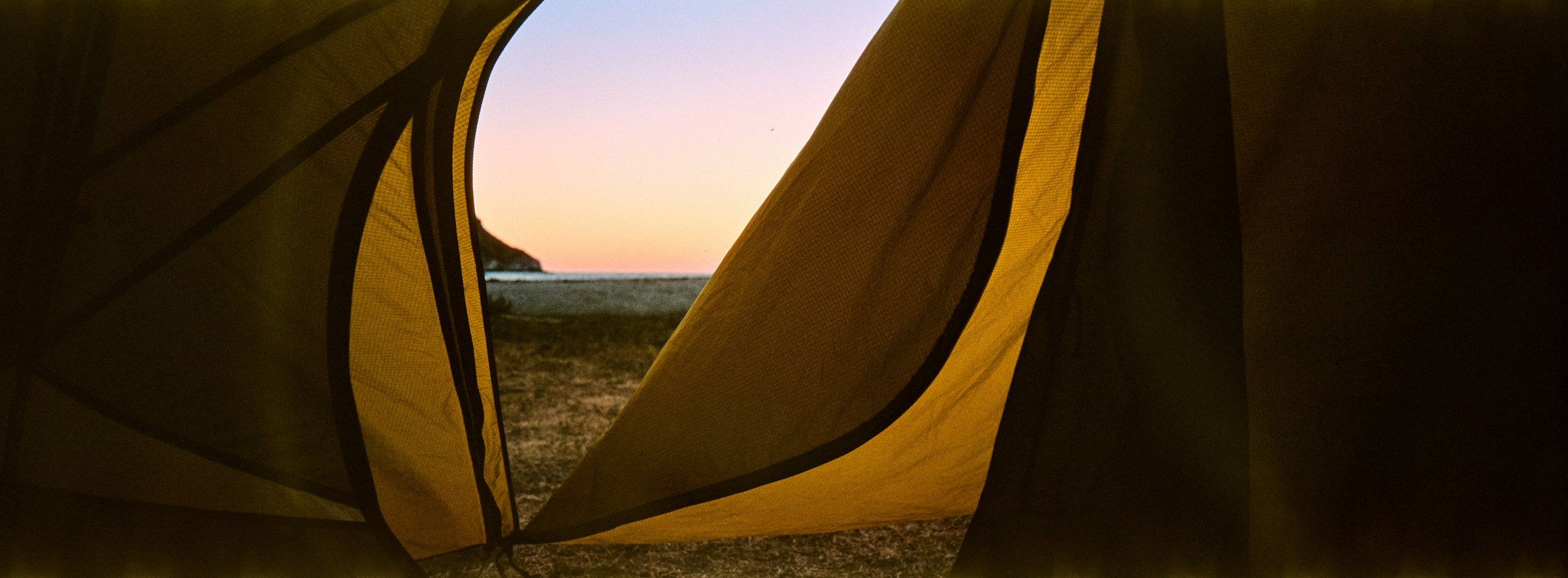
I did a quick scout of this campsite. I made an extremely smart move to take a screenshot of my campsites before leaving Avalon this morning, and that was extremely important because I wouldn’t have known which campsite I belonged to – there is no welcome mat or a piece of paper indicating. Each campsite came with a nice bench, but the random spot I chose had zero canopy. I quickly set up my tent under the tree. Quickly is a strong word, because I hadn’t set up tents this season except for a quick one-night stay before the Volcanic 50k, and I’m getting rusty. The sun is slowly inching off into the Pacific Ocean, and the wind is blowing cooler wind onto me. The campsite was full of people, but everyone was hidden away in their tents. The only people I saw were a group of four but they did not seem interested in chatting with me. Then, the lone hiker behind me made it, and I checked in with him about the bison situation, which he did not see at all. He did mention that he was running around town in Avalon to buy a tripod and earphones that he forgot to bring, only to have forgotten to buy propane! The most important thing a backpacker needs. Aldo and I made a quick arrangement, I would cook my dinner while he set up the tent, and I’d lend him my gas. First human interaction on the trail!
Dinner was easy because I brought freeze-fried Peak Beef Stroganoff and the Jetboiler got the water going in a minute or so. I even made the smart decision to bring a spoon rather than a fork by pure luck – I can’t imagine drinking soup with a fork. The instructions clearly state to use 1 cup of boiling water and leave it for 10 minutes – but dear students, how the heck do you measure 1 cup of hot water when the sun is going down and the wind is blowing? I dump all the water content in, which is probably way more than what I ought to have done. Though the meal was filling, it was still dang salty. I can’t imagine if I had used less water. The sun sat as promised at 1700, and I retreated into my tent after passing the gas canister to Aldo. Then, the waiting game begins. You see, the sun does not come up until 0600, and I think there are even some rules that hiking is only allowed during daylight. Using math, I calculated that I had 13 hours of darkness. I have a headlamp, but I had no plans in the dark. There is a very clean pit toilet, but it wasn’t like I could wash my gear in there. It was also getting colder and the only warm clothing I brought was a very thin rain jacket, so I hid in my extremely comfortable down jacket and read Infinite Jest on my Kindle. There is supposed to be cell service according to some, but I didn’t care to check or needed to drain the battery. I read an hour of Infinite Jest until my eyes are done. Infinite Jest and I have gone a long way – I’m a little more than 50% through the dang book, it is the only book I’ve been reading since I last connected my Kindle to the internet, and it is at least 6 years old. It is a repeated joke I use for new dates when mentioning my reading habits, which I do not think anyone has liked enough yet. And I’m done with the book tonight. Bedtime by 1900, when was the last time you did that voluntarily?
*****
Day 2: Black Jack to Little Harbor
Today is going to be an easy day, a few miles here and there. There is no rush, the weather is cold, the sun rises at 0600 and it doesn’t even get warm for a little bit. I know people were leaving early and I could hear them once I was up. I’m pretty sure it was slightly windy all night last night, and a huge mist (or fog), even rolled in after sundown, and the campsite had very little visibility. So, it was a surprise in the morning when it was calm and beautiful. I might be one of the last to wake up, I had an amazing sleep – it is easy to have great sleep after a long day, especially when I was so cozy in my sleeping bag. Made my breakfast and watched the last few people roll out of the campsite. Aldo and I had a quick discussion, and he was going to go check out some local peaks on the map, which I was hesitant to do since it wasn’t on the official map and there was no sign to indicate that the view was good (i.e. no cool Instagram logo on the map).
I need to get better at camping and decamping. I probably took 45 minutes to do either, whereas I see people get things done in 15 minutes. Of course, it is not a race, but man I’m slow. I would like to blame it on rustiness and that my stuff is just bigger, but deep down I know I’m slow, and it is something I can get better at. After cleaning up my tent site and fully loaded, I was ready to leave. There is another reason why I was so hesitant to leave this morning. The next stop is the Airport in the Sky, where there is a restaurant where I will be getting the world-famous Bison Burger. One thing most people do not know if you are not a hobbyist pilot is that all the little airports dotted across the United States (and possibly the world) is that they usually have a diner attached to it. Most of the time, the food is no worse than roadside diner with similar price points, but you get a great view of planes taking off, and there is almost always no crowd. So, I get to grab lunch there today, at least that was the plan. However, the airport is only two miles away from the campsite, so it made planning the day very difficult. Do I want to get there by 0900 and stare at the planes, or roll out of bed late and try to reach there at 1100 for an early lunch? I settled for some time in between, leaving the boring but functional Black Jack campsite at 0830.
The next two miles flew by fast. I managed 30 minutes/mile, which is a brisk pace even without a pack. I would like to attribute that to a very good night’s sleep, and the amazing cool weather. The sun is up but the heat has not arrived. There is also not much climbing for the foreseeable future, until the end of the day, so the little dips into the canyon and back out were not too bad. Unfortunately, that also means it is kind of a boring landscape. The ocean is still too far out, and the only interesting sights are the satellite tower at Black Jack Mountain and Mt. Orizaba (the highest point on the island). Otherwise, unless a car zoomed past me, it was just me and brown trees. I was not even able to observe the airport, where the cafe and my salvation would be!
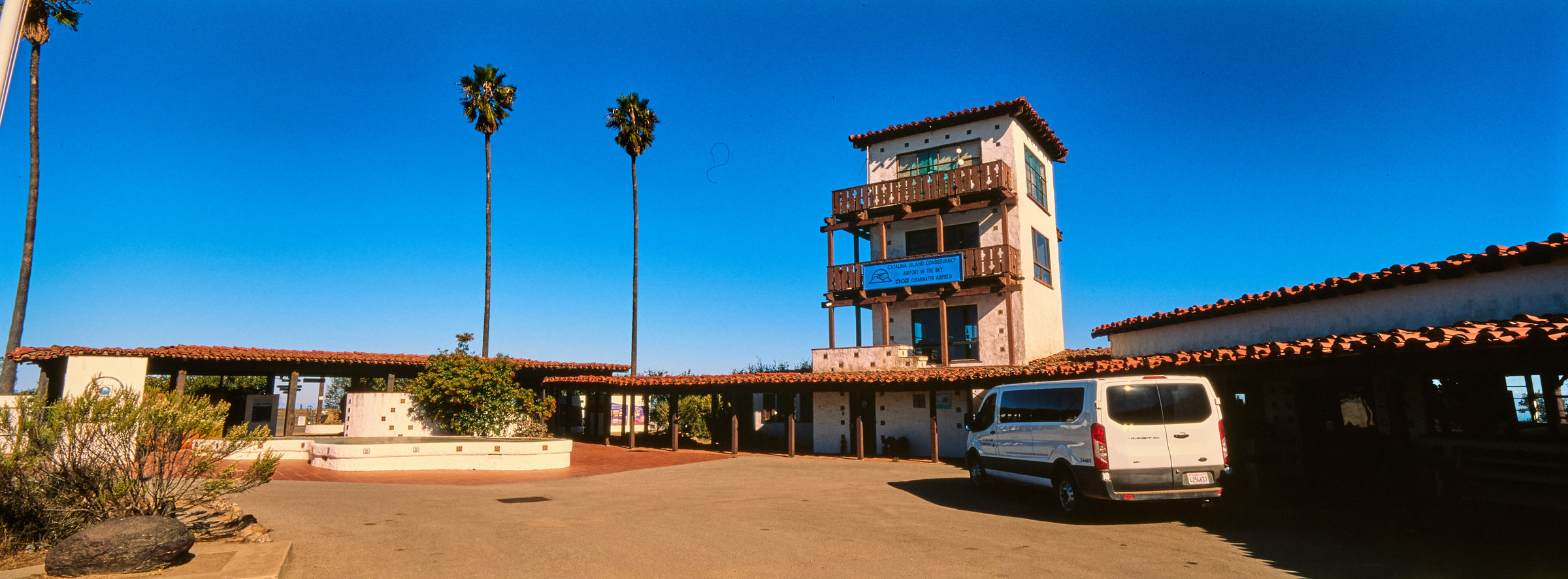
The Airport in the Sky is located at mile 13 on the TCT, and I just stumbled upon it after going up a steep road. If it wasn’t advertised as an airport, I would have assumed it was a depot or south. There is a huge adobe building, with a great 180-degree view to the North where I just came from, but calling this an airport is a very hard stretch. Sure, planes land here, and the U.S. military does borrow this for practice (and used it during WWII), and even the big fat Douglas DC-3 landed here and continues to use this landing strip… But if this is an airport, so can many deserted shopping malls across the U.S. Anyway, I was still excited about the restaurant and dropped my backpack. There is a hiker here already but left soon after I arrived. There was another couple who were arguing (seems like she was jealous that he was looking at another girl’s Instagram or something?) so I avoided them. Got my electronics topped up while I looked through the little gift shop. It was still too early for lunch – it was 0930. So, I just chilled, stared at anything and everything, and finally called it at 1000 and ordered the world-famous Buffalo Burger, and a much-needed cup of coffee.
I was hoping the bison burger (or buffalo as Americans think they are) was locally sourced, but I think it is a frozen patty. The patty just looks too round to be made fresh, and I don’t think there is a food processing plant on the island. It is an expensive burger, but at least the salad and the toppings are fresh and tasty. If I do this again, I think I would recommend eating breakfast here instead of a burger and eating the food in my stash for lunch later – it is just a much better plan logistically and nobody is missing out on eating a frozen patty. I was wondering if the ingredients were airlifted here, but probably a truck drove it here. I did see a few trucks on the unpaved gravel road. Anyway, there was nobody else, and my food came out quickly. The arguing couple seemed to have bailed their backpacking trip and got the van to drive them somewhere else, and another van dropped by with a few tourists, but nobody seemed to be eating here. So, I had the place to myself, and I just chilled as long as I wanted. There is no rush today at all.
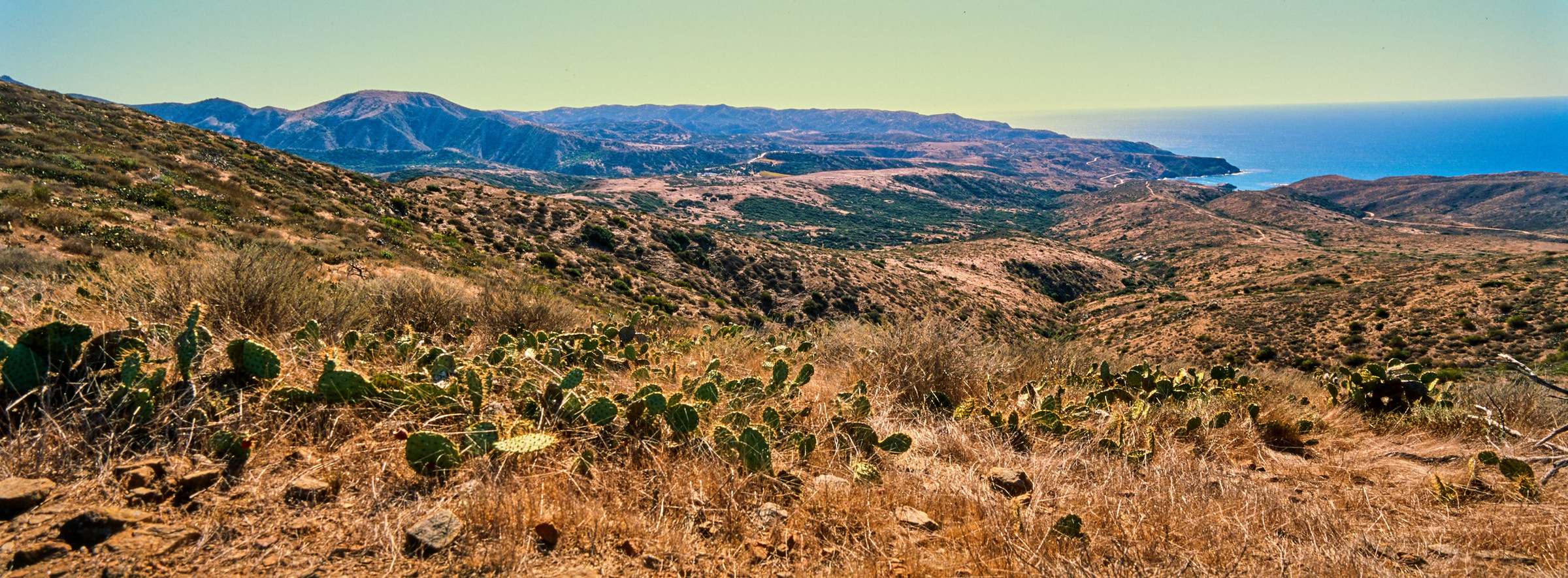
After refilling my water containers, I left the airport at 1030. The sun is still out, but the temperature has crept up. I was hoping the view would change but it is still like rolling brown hills for the next 2 miles. I passed by another pond, but the water looked so brown that I was glad I did not have to drink this. I do wonder how wild animals are able to survive on these, then I remembered our ancestors probably drank these as well. We are so spoilt. The TCT is not exactly a specific trail, but a combination of roads and other trails, and this portion was on the Empire Landing Road. I did cross a few more day trippers (from the size of their packs), though I do not know where they came from, or where they are going.
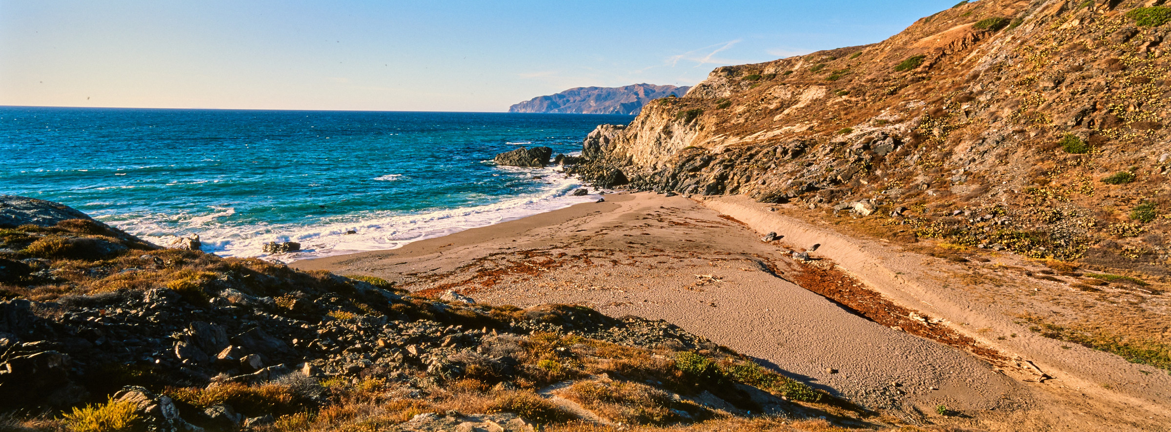
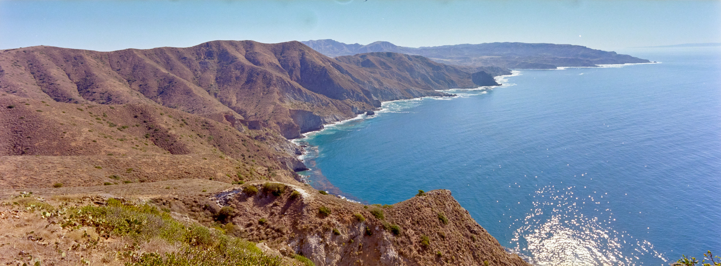
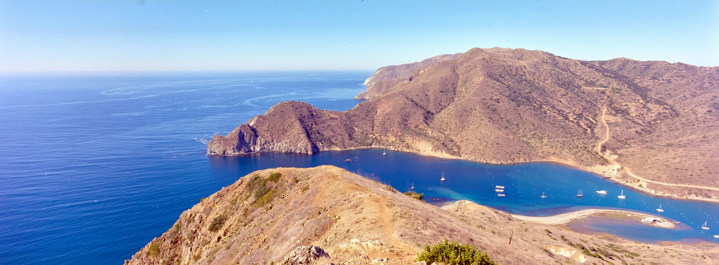
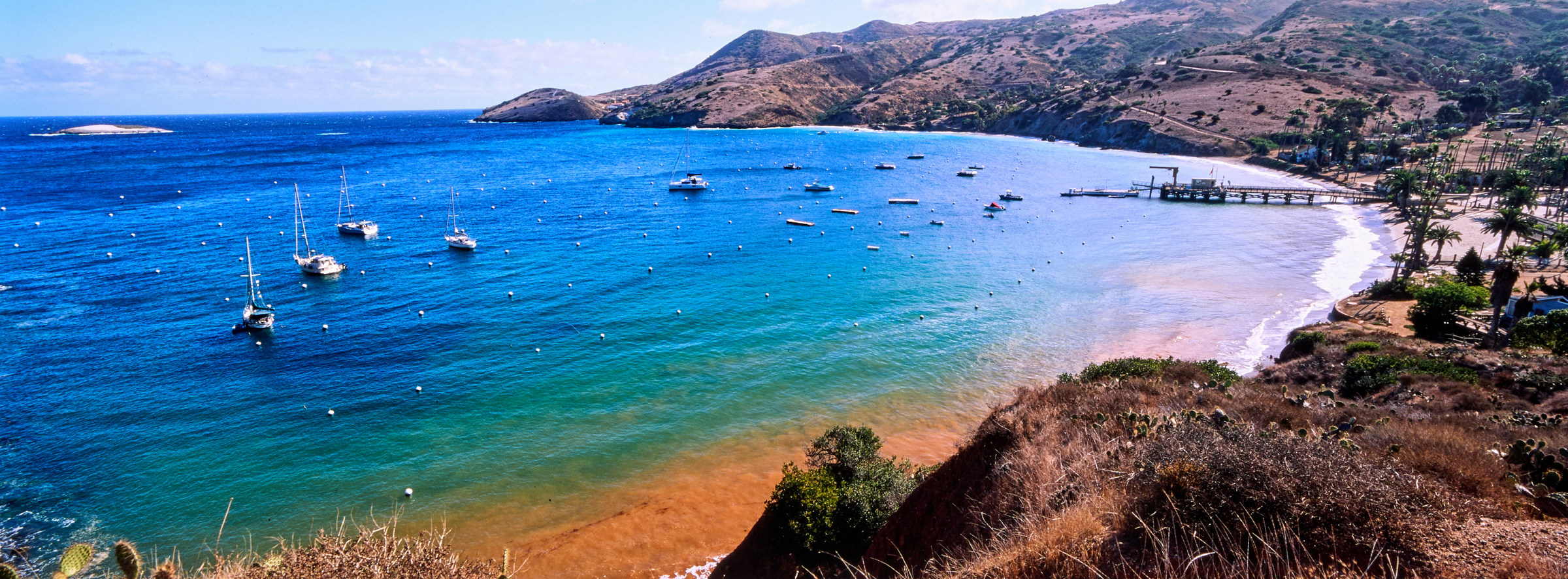
At mile 15, I turned into the Big Springs Ridge trail. There are only 4 miles left until I hit the next campsite at Little Harbor. I do not even need to stop for lunch, and it is only 1130, and the best part is, it is 1000 feet downhill from here. This portion was all downhill on a slanted plateau, which is great for spotting the cove that I’m heading towards. It looked much closer, but I was getting excited about the clear blue water. However, this is as lonely as the trail gets – I did not spot another soul on the trail as I slowly descended into the cove. One of the cool things I noticed on the TCT is that there are almost always tall palm trees (whenever possible) in any civilized area. As I get closer to the cove, the palm trees grow taller and it just seems like paradise. Blue sky, blue water, tall palm trees swaying against the breeze, and even a beach? It is doubly awesome when I have been rolling in brown dirt for the last 24 hours.
Besides the quick stop at the shelter at mile 17, to try to empty all my water, I ran towards the cove. I rolled into the amazing Little Harbor at mile 19 in record time, this place is so beautiful, and I would have loved to live here. I’m not sure if this place is ever packed, but even if it is, the campsites are so far apart and everyone got a slice of paradise. Well, my slice was much better because my campsite was literally by the beach. As much as Little Harbor is beautiful, I was told that the beaches further south are even better, and since it is only 1400, I have three hours set on the timer before sunset. I put all my things into the Fox box, took out a daypack, and left!
My original plan is to get as fast as I can to the further beach, Ben Weston Beach, then backtrack to Cottonwood Beach before dropping down to Shark Harbor and going onto the Whale’s trail by sunset. The issue is that these beaches are not as accessible for hikers. The only way to get here is to walk on the road, which is very steep and hugs the contours of the cliff, making it extra-long. For most of the first mile, as I leave Little Harbor, the view gets better as I climb higher. One last grand view of the cove, and I headed south, which shows even more climbing and distance I must cover until I can cross over this unnamed ridge. This is what I looked at the time and decided that there was no way I’d be able to make it to Ben Weston Beach, and settled for just Cottonwood Beach. There are lots of short trees and thick bushes in this portion of the cliff. This basin seems to be fed by some reservoir or sort, and the stream is flowing water, which is not something I’ll see for the rest of the trip. There was even a cop car who passed me on the road and asked if I was alright – I did wonder what she was doing out here… Should I be worried or am I the crime? I enjoyed the little hike without my backpack and dropped down to a trail marker at around two miles from Little Harbor, but realized that the unmarked trail was way too steep to be a hike and came back out. It was a lucky coincidence that I saw an island fox in the bushes, who slowly walked away while I tried to descend. So majestic!
The real trailhead down to Cottonwood Beach is marked, and the beach might not be as big as Little Harbor, but it is a very nice sandy beach and the entire desert. The hike down is manageable but it is still kind of steep, and I enjoy seeing the waves crashing into the rocks while I enjoy another piece of chocolate. Looking at the time, I decided to head back, leaving only one single set of footprints on the untouched sand. I’m sure it is more crowded during high seasons… or possibly not? The hike back to Shark Harbor is as entertaining as any walk in a major city along a busy highway. Not great, and I had to jump into the bushes a few times when vans were speeding past me and kicking up all the sand, leaving me in a fog of dust.
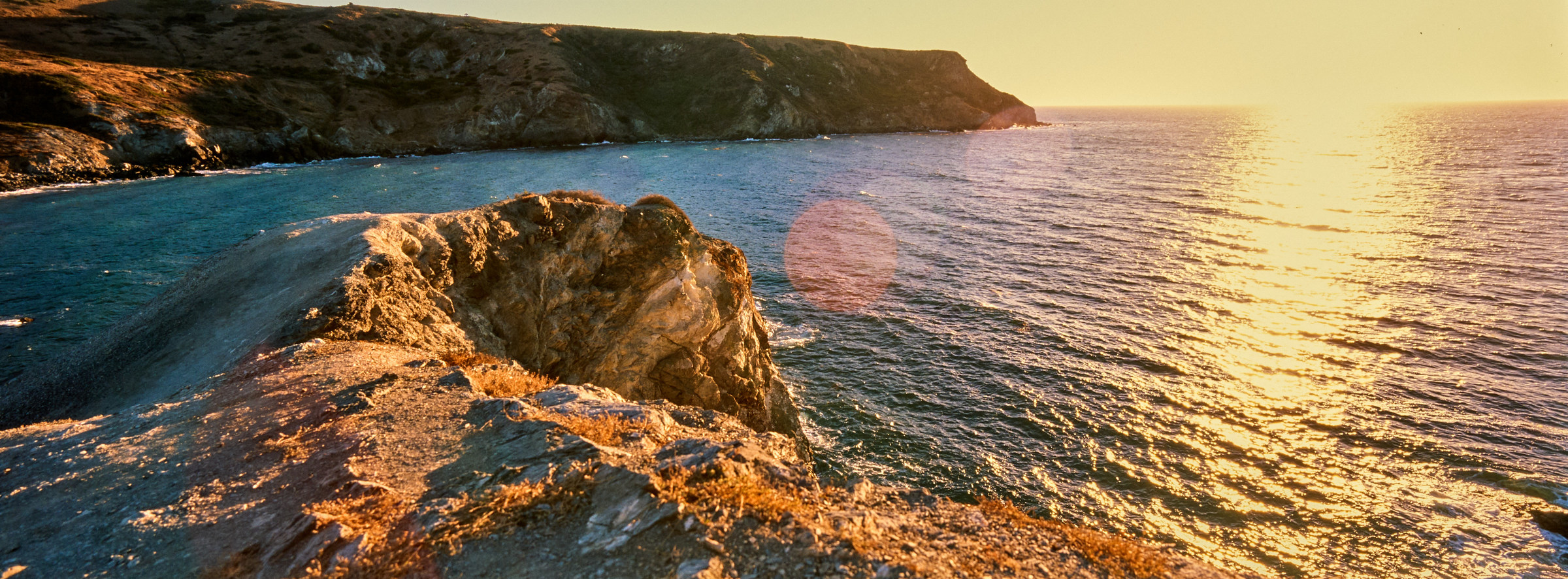
Once I got back over the ridge, I could see Little Harbor again. There is a set of trails straight down to the beach, marked “Trail”. Definitely sketchy and steep, it is better to have come up this than go down, but I’m taking this shortcut, nonetheless. This major cove has two different beaches – the smaller beach is named Shark Harbor, while the bigger one is named Little Harbor. I bet there is some history to this, but I did not bother to find out. The two beaches are separated by a huge rock that looks like a Whale’s tail, and thus its name. Little did I know that there are three campsites on the Shark Harbor portion, and I had to scramble up a user trail and scramble even more to get onto Whales Tail. It is slightly sketchy, but the view of the cove and the ocean is rewarding from Whales Tail. I looked back onto Catalina Island and could only make out one other person on the beach. The rest of the campsite was deserted. Ironic, because rumor has it that most of the campsites were booked. I guess people do not show up since it is cheap to just have a reservation. Just pretty sucky for those who could make it but have no reservations.
I dropped down from Whales Tail and headed to my campsite to see Aldo enjoying his drinks and waiting for the sunset. Managed to do 5 miles in the three-hour time limit I had! As there were still lights out, I started setting up my campsite while chatting with him, who helped me and showed me all the functions of my tent, including the correct way to tight it down. I’ve never bothered to read the instructions, and this might be one of the few times when learning the correct way of doing things would be important. But Aldo taught me the right way, so now I know! Then, the sun was about to set, and the few campers for the night came to the beach and enjoyed the few moments of golden light, before the warmth left with the last of the sunray. This is also when I noticed a few house cats are living at this campsite. I’ve never seen cats at campsites and thought they were cute… But they started to walk towards my tent and my bag, which I assume meant they were after food, and I was less keen on having them around.
I made dinner on the bench – it is not quite dark yet, but visibility is dropping quickly. Tonight’s dinner is chicken curry, but it is not amazing. Salty. As I was eating, I could see the cats were excited and tried to look cute, but I shooed them away. Then, I heard weird noises near my tent and thought that was just wind. As I put my stuff away, I turned on my headlamps and saw one cat trying to claw their way into my tent and the other was waiting! Now that’s not good – nobody wants to sleep in a tent that can’t be fully closed. They ran away quickly, and I did not want to leave my tent alone for too long. After chatting with Aldo (who camped much higher up), he recommended putting everything I have that might have a smell, including toothpaste, into the fox box. I have heard that wild animals are attracted to scents, but it finally hit me that any chemical scent is interesting to hungry animals, so I did just that. I know the cats were out there all night, but as I lay in my sleeping bag reading the Kindle, they seemed to have given up and did not try to break into my tent again. What a day!
*****
Day 3: Little Harbor to Two Harbors
The glory of camping by the beach is to see the alpine glow in the ocean in the morning. The sky is painted pastel pink, and the little waves crash gently onto the seashore. If the cats were scratching my tent, I slept through it all and had no idea. I’m up quite early to use the bathroom, far from my tent site. As I was making breakfast, people had already started leaving the campsite. I was living on the assumption that everyone was doing the same 5-day 4-night trip, but most people were doing some kind of a remix of that – either the lack of days off or lack of campsites available. Though this is going to be a very short day for me, it is going to be long for a few other hikers who are combining Day 3 and Day 4 of my hike, going from Little Harbor all the way to Parson’s Landing. Anyway, I was enjoying my breakfast by the ocean, and still shooing away the cats who started running around the campsites again. I’ve decided to eat my lunch for breakfast, so I can easily eat the bagel for lunch without preparation. This morning’s breakfast is Beef Bolognese, but not good. Seriously, I rather eat the bagel. I’m kind of excited about the next part, because all I must do is to get in the 6 miles, and I’ll be in paradise. There will be a shower and cooked food and a nice bed! I’m not exactly missing those amenities yet, but you know, paradise is hard to beat.
After dragging my feet, I got everything ready by 0800. And to nobody’s surprise, I was the last person in the campground – I’ve seen hikers leaving and heading up the steep mountain. After two days of fun hike, I’m getting thrown directly at a stone wall. To get to Two Harbors, I’ll have to cross the mountain again, which means hiking over 1200 feet of elevation in 3 miles. That did not sound too bad, but it does look bad seeing others going up. The weather is still nice – I think I’m starting to understand why people love the LA weather. I might not appreciate it when it is warmer in the summer, but it is perfect currently, a bit cool in the morning, and very comfortable the rest of the day. Perfect hiking and camping weather. So, it wasn’t too bad to slowly climb up the hill, seeing the little paradise that’s Little Harbor being lower and further away.
The hill did give up for the time being at mile 1, and I ended up on a huge plateau. The island still does not have much tree coverage, which allows me to observe the few hikers who are ahead of me, and I was dumb enough to think I could possibly catch up to them. I tried. The plateau is flat but sloped upwards, but it is easy to hike, and I was happily going along until I noticed a big brown thing just ahead of me. A huge bison again! This time, the bison is much closer to the trail, but the people ahead of me probably just passed it, so it is fine? I slowed down and thought hard, and slowly inched towards the bison. Initially, the bison ignored me, then noticed me, then finally, stared at me – that’s my warning so I slowly backed off (and I’m still far away). The other hikers ahead of me were watching me from afar, or at least that’s what I thought. After I backed off, they left – I guess nothing to see here. I dropped my bag down and waited. Unlike the bison on Day 1, this one doesn’t really care to eat the grass exactly here (among an entire plateau of grass) and just wanted to show who is dominant. The bison lifted its tail, which looked funny, and took the biggest dump I’ve ever seen. It is like a sewer pipe burst, and brown water gushing right out. It would have sucked to be anywhere close to that! After it finished, the bison walked off into the valley, which meant my 10-minute break was over and I was able to continue my walk up.
Looks are deceiving, as I can easily see the trail leading to where I think the highest point is. (there is a nice shelter at the top!) The trail has lots of loose gravel and is alright when the slope isn’t as steep, but it does get slippery when it gets steeper. I took a break at mile 2, after climbing some steep portion, and I let a few more people pass me (where did they come from?!) There was really no rush, and I was starting to build up a sweat and did not want to soak my bags and cameras. Once I’ve dried off, I continued the plateau. Since the steep slopes, I’ve lost the view of Little Harbor, but I’m now on the mountain ridge and can see the ocean once again, and even Black Jack Mountain in the south. The view is somewhat interesting, better than Day 1 and Day 2, but mostly the same as I continued on. As I got closer to the top of the hill, the slope increased in difficulty again, and I wish I’m exaggerating they decided to put a 20+% incline for 0.5 miles, all the way to the top of the hill. This is one of the few times where I wish there was a little bit of switchback, not just to reduce the steepness, but also to help prevent erosion. The trail we are walking on is basically washed, and I have no idea how people can come down here. In my opinion, it is much easier to walk up this crappy trail as it is just difficult; coming down would be difficult and sketchy. I took a break, then went all out on this last portion of the hill. There is no way this portion is harder than Day 1. I would rank this portion as challenging, i.e. 4/5 on the difficulty scale.
By the time I rolled into the shelter at mile 21.5, all sweaty, everyone just left Which is fine by me as I got an amazing view all by myself. It’s around 0930, and I decided to just eat my lunch here. There will be more food and fun things later in the day, so I’m not going to conserve my calories. Took a 20-minute break, just enjoying the sea breeze, and tried to cool down once again while seeing the next hiker trying to tackle the hill I just came up. I could also see the hikers in front of me disappear into the ridges, only to reappear on the other side – this is basically a preview of what I’ll be doing. I also did a quick study of the map, as I plan to take a detour to the Cat Harbor Overlook and needed a separate route. I repacked and was ready to leave and realized it was Aldo who was rolling into the shelter and waiting for him to survive this hike. After a quick exchange of pleasantries, I left off, this time, all downhill towards Two Harbors!
Actually, not so fast, as for the next 1.5 miles, I continued towards the settlement on a rather pleasant walk, mostly flat but slightly downhill. There was a next shelter that was coming up, and I thought that was where the trail was leading us, but we were dumped onto a Y-junction next to a cell tower, and my extra trail started here, and I had to climb up over a hill on a very rough dirt road (How do people even drive on this?!). I managed and realized my final destination was the shelter, which looked way further than what the map says (around a mile) I slowly inch towards it along the cliffside, and the views of the ocean right beneath are gorgeous. Suddenly, I saw another hiker coming from the opposite direction, and he was waiting for me. We exchanged pleasantries, and I found out that this was basically a midpoint for both of us, as he was doing it in the opposite direction. Moreover, he came up straight from Two Harbors took a wrong turn and used a really steep user trail. I told him the worst was almost over for him, and we left.
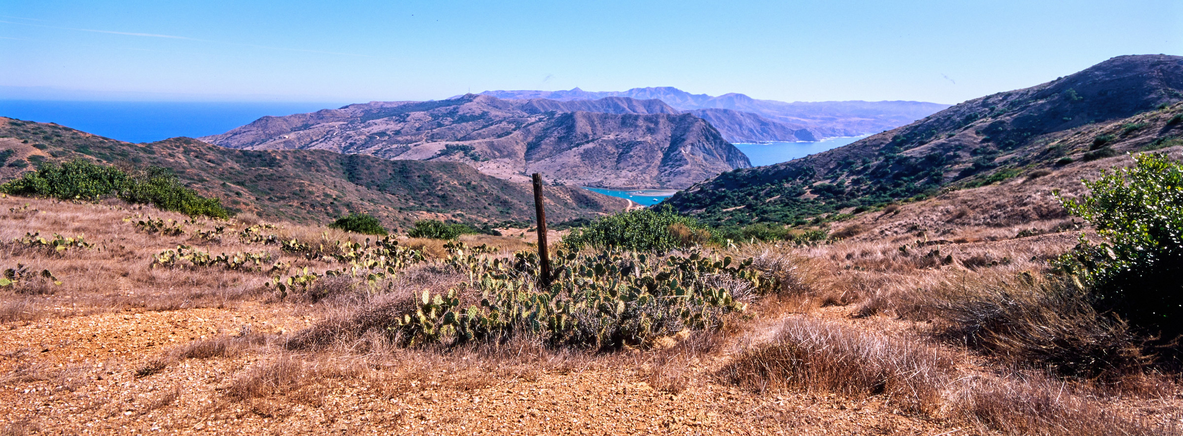
Had I headed straight for Two Harbors, I probably would have been there by now. Instead, I’m still too early. It was only 1100 when I got Cat Harbor Overlook. The view is stunning, I can see the isthmus that Two Harbor is on, the water looks so beautiful and so are the ridges on the mountain on the northern portion of the island. The wind did not stop howling the entire time I was here, and I was worried everything would be blown away. I decided to burn more time here and sat for another 20 minutes – not a single soul decided to do a day hike up here and I had the spot all for myself. To be fair, I don’t think it is worth coming from Two Harbor, since the climb up seemed a little ridiculous, so that might be the reason there is no one. Or that it is low season so there is nobody to begin with.
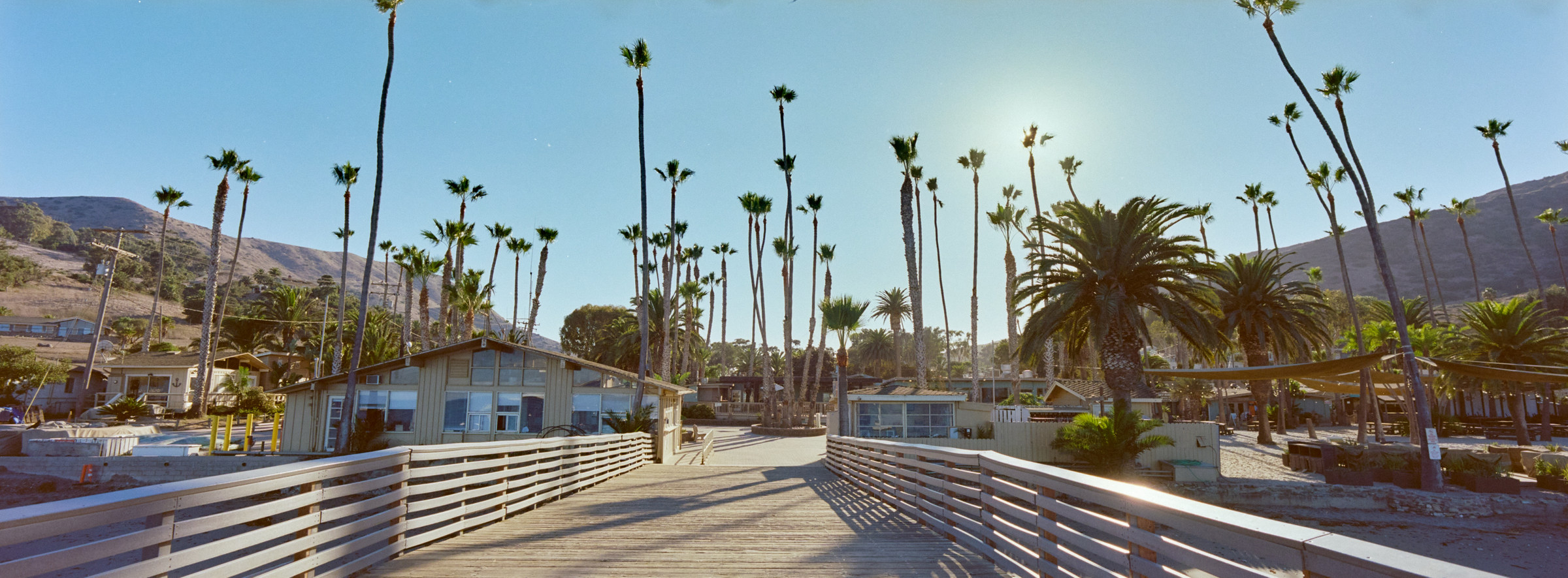
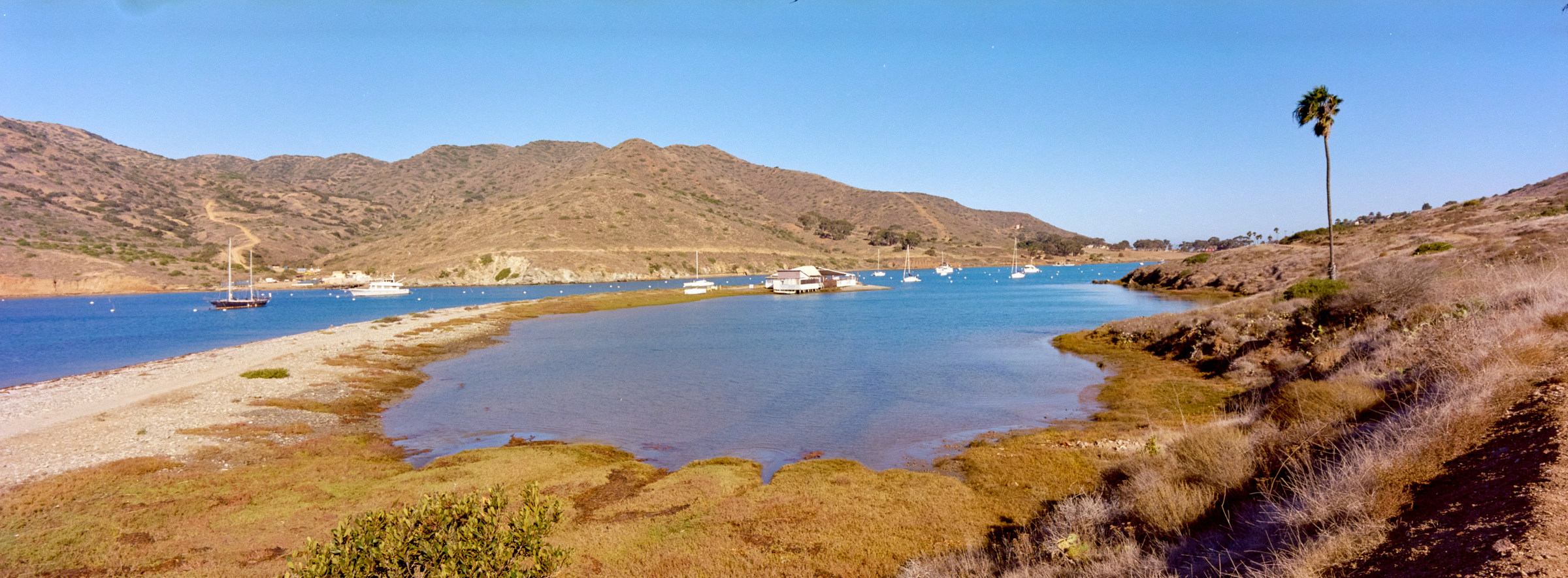
I have two more miles to hike for the day to get to Two Harbors, and it is 100% downhill. I’ve seen Two Harbors from the overlook, and once I got back to the Y junction, it was basically straight down. I hadn’t had internet for a few days now, and I did not even know where I was staying for the night. How hard can it be to find the only hotel in town? The isthmus is cool – a thin strip of land surrounded by bodies of water on both sides. The only other isthmus I’ve been to is Madison, but that is not as close as this. If you don’t like one side of the ocean, you can go across and look at the other side! Anyway, I could see the famous palm trees and got more excited. My plan is to check in as soon as I can, do laundry, and just chill the rest of the day. Maybe even go into the ocean! That would be so nice.
I was so high in my thoughts that I did not notice the first few buildings I walked past. I’m already in Two Harbors! I still have no idea where I’m staying, and switching on my phone did not yield any signal. As I slowly walked down to town, I saw a sign that said, “Towards Banning House”, pointing to a trail going back up… Dang, I missed it, I followed the steps and tried to find the office for check-in. It was really empty, and I couldn’t even find anyone working until I completed a walkaround and found a tiny office in the corner. The receptionist knew who I was (it was an extremely low season) and passed me the key to my room even though it was being freshened up. It was only 1200, this might be the earliest I tried to check into a hotel – I’m usually extremely late. I took the opportunity to eat a free cookie and enjoy the amenities. Before I even sat down, my room was ready, and I decided to take a nice shower, air all my camping equipment, and take the most awesome nap.
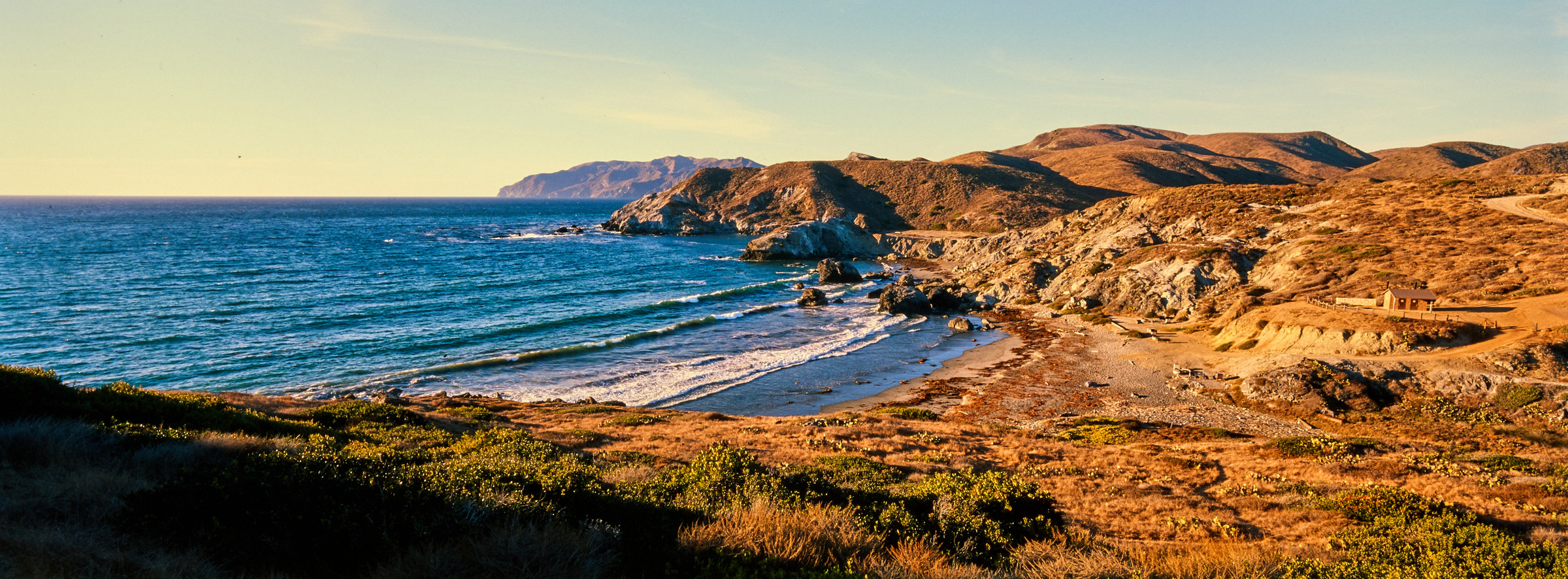
Life’s good when I live in paradise. After my greatest nap of all time, I decided to check out Two Harbors. I cannot emphasize that I imagined the settlement to be much larger. It just seemed like there was more going on. The receptionist told me that the water facing LA is much cleaner than the one facing the Pacific Ocean because people are living in the second one. Either case, I did not go into the water. I brought my laundry to the only laundromat – I literally just walked to it without any signs. Then, I walked around the area during the wash cycle. There is a little shack that acts as the office for the Conservancy and also sells boat tickets. A few people were chilling in the outdoor cafe, and the cafe served lots of hot food and drinks. I assumed the few people were waiting for the boat to pick them up, heading anywhere else but paradise. The cafe also acts as the town’s only restaurant in the evening, but close whenever there are no more businesses. Remember Avalon, the bigger town on the island that has many shops catering to tourists? Ironically, they do not carry any products or souvenirs on the TCT. The only place to get a shirt or a hat is at the super-grocery-all-in-one shop here at the general store, the last shop in town. They are extremely well equipped, ranging from groceries to souvenirs to flip flops and tasty drinks. This is when I regretted carrying freeze-dried food all the way from REI – I would have rather paid $1 more to not have to carry the last 20 miles. I did more walking around while the dryer was running and overheard something about ferries not going to run on Friday, though I was not paying attention to that. The beach here has a resort feel, with a nice sofa and even little shops set up to serve the patrons, except it is closed for the season, so I have even more paradise for myself. What an odd feeling.
I’ve decided to enjoy my hotel amenities around sunset time. The Banning House was built by one of the sons who bought the island, as he preferred to live in this area over Avalon. I kind of agree – there are mountains in the North and South, and two coves in the East and West direction. There are around 10 units here, all of them are extremely luxurious, and I got access to the amazing lodge and could even start a fire in the fireplace, though it was not cold enough for me to do it. The views from the lodge down both coves are amazing, and the sun is hitting Two Harbor amazingly at 1600. Most of the employees were about to leave at this time, and there were going to be only two other groups of people staying for the night. I was hoping to mingle with the cool folks during the free afternoon cheese and wine party, but I was the only person around and got a huge plate. Oh well, I took that plate, found a great viewpoint, and enjoyed my snack plate watching the sun slowly set. The unfortunate thing is that the mountains to the north are so much higher than Two Harbor, that the sun gets blocked a lot earlier than sunset at 1700. There is no sunset view tonight, though the blue sky slowly turns pink, and I will accept that as a consolation prize.
I might have my huge plate of snacks, but I still should eat dinner. I even delayed eating by a little bit, but I was worried that the restaurant would close early, so I headed down to the only town in the vicinity and walked into the only bar in town, right next to the cafe and the grocery shop that I was in. I basically just walked into the only place where the door was open, and I think the entire town was there. The people who worked at the hotel even sat next to me at the bar, which was surprising and funny. Unfortunately, the prices here do reflect the exclusivity of the location, but there were Happy hours for some reason, and wings were 4 for $3, and I couldn’t say no to that. I also wanted some fresh vegetables, the first time I ordered salad out. And while I was asking for Hop Water, the bartender decided to just give me a 0% Heineken, and so I had the most expensive bottle of non-alcoholic beer in the world. Cheers. The food came out fast and was very delicious, despite all other things. They could have microwaved food and people would still pay whatever the asking price, but this was better than that. I didn’t spend too much time at the bar, though it was getting “crowded”. The bartender did mention that he closes when he doesn’t think more people are coming, so who knows when that happens. The rest of the night was just me enjoying the most comfortable bed in a little while. I really did not mind sleeping on the pad, but the upgrade is just so much better.
*****
Day 4: Two Harbors to Parsons Landing
I have no reason to wake up early. On one hand, I know I have to do some insane climb out of Two Harbors, on the other hand, it is going to be only 6-ish miles. So, I slept in as much as I could, rolled out of bed, and enjoyed the best breakfast one could ever have. There are two other rooms of people, but I did not see any of them until they were about to check out. So the breakfast buffet was just for me. There was one thing I had to do before leaving for the day, to get the locker keys for Parsons Landing. Unlike the southern portion of the Isthmus/Island, there are no water refilling stations in the northern portion, and my only water refill will be at the campsite tonight. Everyone who is camping would have paid for the locker, which comes with 2 gallons of water and a bundle of firewood – things that we did not have to hike 6 miles with.
Once breakfast was over, I went to collect those precious locker keys (which are just a key code). I noticed a few people headed out towards Parson’s Landing, but it was still too early. I would have left early, but the ranger had told me that Starlight Beach is unreachable due to extreme erosion on the trail, so I am taking this extremely easily. The one thing I did do was to head to Ballast Point. This is a road that’s a mile long and looks easy enough for a fun morning hike. There was no Instagram logo, so I assumed it would be a bust, but I couldn’t think of anything else to do and headed there. The dirt road follows the East/Southern portion of Catalina Harbor (The one that faces the Pacific Ocean and is supposed to be dirtier), and there are a few lodges for the local yacht clubs and mostly fenced off for the public. I almost turned around early, until I realized that the road was not closed, and continued. I could see the hotel I was staying at, as well as the shelter at the end of Cat Harbor Overlook, some 750 feet higher up in the sky. The view of the harbor is alright, I assumed the spit is named Ballast Point, which is where the road is bringing me. There was a little climb, and a bench faced the spit and the harbor, but I noticed the road continued a little more, so I kept climbing and reached the end of land. Well, well, the map might not marked it, but I thought this view facing the Pacific Ocean and Catalina Head (the slope on the other side of the Cataline Harbor) was incredible. The water is that deep green teal, superimposed on the brown dirt and blue sky, with the nice breeze – why is this not marked? Of course, Cat Harbor Overlook from way up there is better, but this is so much easier! I’m glad I did not give up at the sight of the first bench, because I backtracked to Ballast Point, and it is just alright, no different from any viewpoints along the Catalina Harbor.
I do have a time I have to leave Two Harbors by – hotel checkout time. I got back to the hotel at 1000, reapplied a ton of sunscreens, and enjoyed civilization one last time, before loading my big bag and heading out again. It might feel long and tedious, but there are only 24 hours left before I circle back and head out on the ferry back to LA. But one step at a time – literally. Officially, leaving Two Harbors put me a bit past mile 24, and the campsite tonight – the legendary Parsons Landing, is at mile 30. 6 miles might sound easy, even to me at this point, but if anyone bothered to look at the elevation profile, they will have their eyes bulged out. Well, not me – why spoil the surprise! I headed out along the other shore of Catalina Harbor this morning, this side has more industrial things going on, so I guess they do have to have people working on the island and have a storage facility for them. Just kind of surprised to see them. The first mile is boring enough, still the same view as this morning, but this time with a 50-pound bag. At mile 25, I turned inwards and started to climb. A sign welcomed everyone to the wilderness again, and I realized how hard this portion was going to be. The sun is beating down on me and there is no shade as usual. Moreover, the nice breeze was being blocked by the huge hills that I was trying to conquer, so I was heating up quickly as I tried to beat this mountain. And yes, today’s 6 miles are short because they had routed us to climb onto the mountain ridge, only to drop back down immediately, as the campsite is on the beach. I was hoping I could do maybe half a mile of hike with 5 minutes of break to cool down, but that clearly isn’t working at mile 1.75, when my sweat is beating down nonstop. I’m glad we have time to burn today! So, I took as long as I needed to cool, trying to hide any shades to not have to stand in the sun. The ravens were croaking nonstop, and I was worried they were going to steal away my smelly hat, so I had to keep watch over that while I hung it on branches to be baked by the sun. This continued for a little while, and I was all by myself. I was wondering if I was the last one on this trail and if there was even anyone doing the opposite direction and coming up this hill, but I did not see anyone while I took the longest breaks ever!
I took a total of 5 breaks between mile 25 and mile 27, and it was almost 13:00. I was getting hungry, and I noticed a shelter, but then I noticed hikers were coming from the opposite direction. Most of the uphill is now over as I’m now on the top of the ridge, and I know it will be rather flat for a little bit. I wanted to grab lunch here and now, but the view leaves more to be desired, and the incoming hikers told me that there is another shelter up ahead. Foolishly, I listened and continued this journey. I would say this portion is the most beautiful part of the trail. On one side, there is the steep cliff down into the Pacific Ocean, extremely dramatic and photogenic. Towards the east, I can see the gentle slope and there is a huge sea that divides us from the mainland, which is never too far away. Since it was a clear day with blue skies, I could even see the mountains further in the distance. Amazing views, and the wind picked up, and I’ve regained my cool. I ate my snack quickly and then headed onwards looking for the next shelter.
At around mile 29, I did find the shelter. I’m getting so hungry, and just flop things down in the shelter and try to boil water. I’m kind of dumb (more dumb than usual) because I have decided that I am going to cook lunch today. Unfortunately, this is the one place where the wind cannot stop gusting, and I have no way to block wind. Moreover, the ravens are still circling overhead, trying to steal anything and everything. I managed to boil water, and rip open the package while preventing any attacks that would land. It was so much effort that I will never do this again – it shall be boring dry food for lunch in the future. I could literally eat, or carry out a sandwich from the cafe at Two Harbors. The silver lining was that the Chicken Tikka Masala tasted amazing, and I have regained faith in freeze-dried package food. Still, it is getting late at almost 1400. I will be able to get to the campsite before sunset, but I was hoping to enjoy the world-famous beach while I was there, and there is no time to do that tomorrow. I packed up quickly and was excited to head down to Parsons Landing. Two miles to go! Just as I left the picnic tables, I saw Aldo! He mentioned that Parsons Landing was good, and that Starlight Beach was a no-go as the trail was extremely washed. As I waved goodbye to him, another couple passed me. They seemed to know what they were doing, and I wasn’t that excited to run to the beach, so I let them go at it.
So, someone mentioned that Day 1 was the hardest. This was proven wrong on Day 3. And then climbing out of Two Harbors today was ridiculously tough – getting to the highest point on the trail at around 1700 feet in 3 miles is hard. But nobody told me about the downhill at mile 29. Okay, maybe people mentioned it, but I didn’t read it. It is a symmetry, so the ridiculously hard hike going up, I will have to go down the same elevation in 2 miles. What is even worse is that once I turned into the Fenceline Road, all resemblance of a trail ended. This is a washed-out sand slope. For some reason, something tried to stabilize the trail, but it made it even worse, and the lines drawn perpendicular to the slope did not hold any weight. This would be a hard hike going down, but it is harder now that my legs are tired, I have so much baggage, and I did not have poles. The couple who was just ahead of me – Bridget and Andrew, both had poles, and they were struggling too (They did walk straight from Little Harbors, so it was an extremely long day for them). For the next 1.5 miles was the thrill of this trail. Every step might be the last step, as one could easily slip and tumble over. I do not understand why the trail is routed clockwise. For as much as it is insane to climb up this sandy hell hole, it is at least not life-threatening. I did wonder – what was the worst that could happen? Would the sand break my fall, or would I just roll straight to the ocean by the campsite? I did not care to figure that out.
I took my sweet ass time and managed to cause any major earthquakes coming down. I still can’t believe it, but it was possible to come down without poles. I would like to take this opportunity to take the years of trail running to prepare for this insane workout. If the climb out of Two Harbors was 4/5 in difficulty, the hike down to Parsons Landing is easily a 5/5. There is no way around it. Folks, if you are still reading, be prepared for Day 4. There is probably no way to train this. Maybe do some black diamond downhill skiing. The last half mile to the campsite at Mile 31 was much, much easier. We were walking along tall grass at this point, and we knew where the campsite was – the cove was visible even before we descended two miles earlier. But as we lost elevation at reached almost sea level, we couldn’t see it. Then, after a few twists and turns, we rolled into a huge sign welcoming us to the campsite. 5 hours to do 7 miles, I don’t think I have taken any slower hikes in my life, and I’m glad I do not have to ascend or descend any longer.
The campsite is fully packed, unlike the two previous sites. The couple and I were the last. There were a bunch of teenagers (probably college-aged but kids these days look so young!) that were just sitting at the couple’s tent site. I thought they were just trying to secretly camp somewhere, but they probably were trying to spread out and take advantage of any empty spaces. I did wonder why they spread the campsites so far – they could easily double the number of sites if they wanted it. I don’t even think the three sites on the other side of the cove were even taken. Unfortunately, my tent site is extremely far, 2nd furthest from the pit toilet and locker, so there will be a ton of walking before I can finish setting up my tent. The tent site is situated on the beach, but there were a ton of rocks that were stacked to make a windshield, much further back from the beach itself. I wasn’t going to reinvent the wheel and just chose to set up tent by the fox boxes at my tent side. Since this is the last stop for most people, there are plenty of leftover gas fuel, and water from previous visitors. I have never felt this equipped. There isn’t much to do besides setting up the tent and making dinner. Sun was about to set but the mountains that I’ve climbed over are blocking the last ray of sun, and we were in shadow the entire time I was on this beach. Definitely anticlimactic compared to what was supposed to be the best campsite. I think Little Harbor has this beaten by far.
The sky did turn pink and the beach looked beautiful in twilight, I managed to cook my dinner without wind, which was an amazing change compared to the afternoon. Some people were going into the water only to run back out – I bet it is freezing cold, and as much as I have water to waste, I don’t think that’s enough to take a shower. I didn’t really want to stay out too late as well, and the weather dropped quickly once the sunset. A quick engineering problem arises. How can I start the fire? The bundle of wood came with a firestarter, but the only source of fire I have is from my Jetboiler. (which clearly states that it should never be used as a fire starter) I tried to light the firestarter (something I’ve never used before) over the jet boiler, but by the time I transferred the firestarter to the stack of wood, it would extinguish itself. I then did the ultimate dumb thing – stick the firestarter in the pile of wood and tilt the Jetboiler to light the bundle. The bad news was, that the Jetboiler caught on fire and I had to quickly extinguish the entire mess; but that also finally lit the dang bundle. Pretty proud of myself considering I don’t know what is the correct way to do this. Can a match even light this firestarter? It looked difficult.
As the fire died down, so did the heat and my desire to stay in the cold. The teenagers still did not set up their tents, and I later found out that they were so minimalist that the 8 of them shared 3 tents, and some of them did not even have rain cover. I think that’s to help with maintaining cool temperatures in the tent, but that’s showing the youth in them. The night is young, but I had to leave early tomorrow morning for the last leg of the hike. Time to get some good sleep!
*****
Day 5: Parsons Landing to Two Harbors
It was all calm and nice when I went to bed at 2000. Most people were enjoying themselves around their fire. Day 5 ought to be the easiest – how hard can it be? But Gods love to play jokes, or maybe we are so tiny that they didn’t even realize we were being caught up in their everyday shenanigans. I have been sleeping with earplugs when I camp outside since there is so much noise that I probably will wake up every 20 minutes. So, the first thing I realized, without any warning at around midnight, was that my tent had flipped over and my backpack which was right next to me before I went to sleep, decided to be on top of me. Talk about not having a partner! I woke up and fixed all the anchors to make sure they were better secured (it is camping on the beach, difficult to anchor in the sand, and I do not have the experience to know how to do it correctly). Did a quick peak around my neighborhood, most people seemed to be okay, but the couples had lights in the tent. I also realized that, even though I did not plan to camp anywhere else, my tent is literally by the water line. The high tide was so high, and brought in so much wind, that the pile of rocks next to me was wet. I later found out that the teenagers did not heed the warning from the couple, and some of them were wet when the high tide came. And speaking of them, that one tent without a rain cover was still in their deepest sleep. Dang, they are out.
I woke up two more times as my anchors kept failing, though the wind might have weakened, and it was never as bad as the first time. I’ve also just decided that it is probably not going to blow me away in the tent, so I trusted in my weight and slept until the sun was up at 0600. At this point, half the people left, and I was worried that I had misread the time of the boat, but it was still leaving just before noon, and I was on time. I enjoyed my breakfast in silence, the wind is still here but not as bad as last night – the nonstop howling is on its own level. After an hour, I managed to decamp and started my hike at 0700. There might be 7 miles left, but it is mostly flat, and it should be a piece of cake, considering what I’ve done yesterday.
The first mile of Day 5 was mostly inland. Most of the land here, or basically the entire coast facing LA, is private and is used for camps, more camps, private camps, and private hideouts. As a result, while mile 31 was on the trail, that was the last of it. The rest of the last 6 miles are on the road that I’ve to share with vehicles. I’m grateful for this road because that’s how they were able to drive out 2 gallons of water and firewood for me last night. Moreover, this single-lane extremely windy dirt road with no guardrail is not fun to drive. I reckon that it might take the driver 30 minutes just to get from Two Harbors to the camp at Parson’s Landing. On the other hand, which is the hand I care about currently, it kind of sucks that the trucks (and other vehicles) kick up so much sand when they pass. Sometimes, the drivers are nice and slow down; other times, they are just on their merry way, literally leaving me in the dust. I do wonder if working on an island allows you island time lifestyle, especially doing work so far remote from the nearest town. What are they going to do? Fire you? Who are they going to find to replace you?
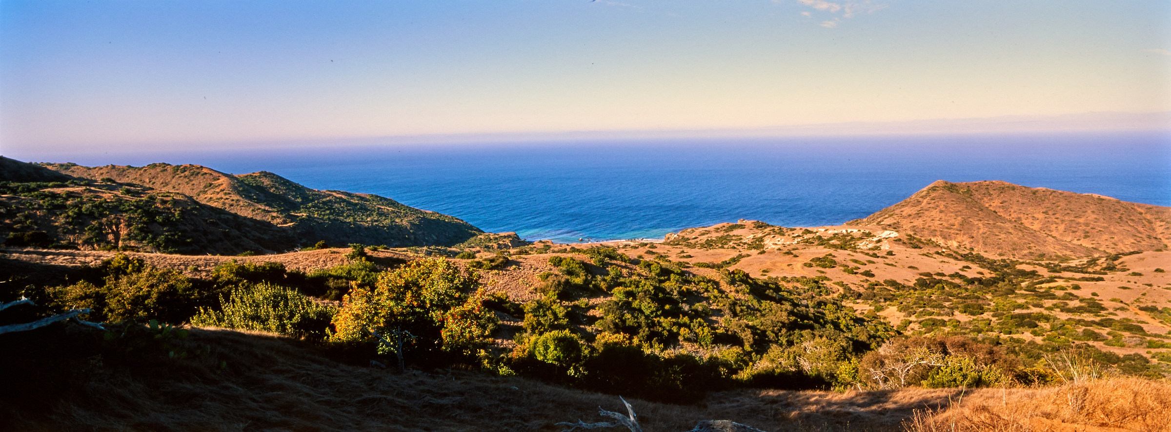
The next 5 miles are a wash. The victory song theme was playing nonstop as I smiled brightly. The road is very easy to hike on, the coast is beautiful to look at, and the sun is getting blocked by the cliffs, so I did not even put up sunscreen. I did notice a few new things now – since the road follows along the cliff, we have to hike extra distances just to get to the other side of the cove, and there is a dozen of them between me and the end of the trail. Some of these coves are not too big and it took no time to get to the other side; one of them was so large, I think I spent at least 20 minutes to get to the other side. There have been brave souls who tried to cut across the cove by hiking down and then hiking back up – I can see that saving a huge amount of time on some of the larger coves. However, the owners are probably sick and tired of smelly backpackers, and there were plenty of signs to remind all to not veer off track, and that the cutting across is always prohibited. It dampens the mood I’m in – the only words I read here are no, no, and no! Also, like yesterday, there are no water sources anywhere along the trail. As a result, there are also no bathrooms – except one almost at the end. That has a beautiful lookout of the Two Harbor though, and they missed an opportunity to have an open-air bathroom, which would have been wonderful. I have seen some of those open-air bathrooms on famous trails in British Columbia. I bet it does not smell good though!
With nothing to do but count down the miles, I’ve begun thinking about the journey. It is coming to an end, and I plan to celebrate it by ordering a huge pizza and eating it before boarding the boat back to Long Beach. I enjoyed this solo backpack trip. I do think this is a baby step towards future multiday backpack trips, and I can optimize my packs in the future. This is one of those pre-requests I’ve been waiting for. I’ve not been able to do some of the fun multiday backpack trips around me due to the lack of planning, and also experience to know if it is possible. With this under my belt, 2025 looks like a year of some multi-day hikes. Would have been nice to have someone guide me on the first trip, but I guess I learned a lot of things by just jumping head in without doing too much thinking – moving abroad, running and triathlon, hiking. I guess this is just the next step to what I’ve done and what I’ll do.
The day was getting warmer as I approached Two Harbors. I had a great time – there isn’t much to stop for even for a photographer nerd like me. There was a team of two men who were only waking up while I was leaving, and one of them caught up to me at mile 36. I’m not sure about the rush, and I was worried that I got the time very wrong. Nope, I’ve built an hour cushion to the boat departure time, and I’m at least 30 minutes ahead of schedule. And with that, I slowly strolled my way into Two Harbors. For some reason, the water here, on this side of the cove, starts from a sandy brown and gradually turns red towards this beautiful teal, and with blue sky. What a beautiful rainbow of colors to greet me at the end of the 37-mile trail. This is when the victory music crescendo!
And the beat drops to dead silence. I navigated my way from the road back into the only cafe in town. I saw the couple chatting at a table, and the two men that rushed ahead took another spot. There were maybe a few more people, and I beamed the biggest smile at the lady I saw on and off, congratulating her for finishing the trail. I made a quick comment about getting the famous pizza before leaving this dang town – and she went “Hadn’t you heard?”…
Well. I thought the toughest part of this journey was yesterday when I have to get over the dang hump. Maybe the early start I must do on day 1 when I have to lug my entire bag to the ferry terminal. But no, life throws wrenches, and this is when I learn to accept it. I love the saying – that the bird on a tree branch is never worried about the branch breaking because the bird knows it can fly if that happens. Also, most problems can be solved by either throwing a ton of money at it or just waiting it out. Anyway, I thought I was a bad camper last night, that my tent wasn’t built properly, or that’s the nature of Parsons Landing. Turns out, even the campers at Two Harbors were hit by huge winds. Gales that are so strong, that all the ferries have been cancelled for the rest of the day.
I did get off the island, and I was lucky enough to space my flight departure from LA by one day, and time was not of this essence. I guess, life on an island means island time is in effect. However, that tale, which I think is way more fun than this ramble that went on for way too long, is not part of the official TCT. As a result, that will be a separate chapter. In the meantime, I did it! I’m not exactly sure how long the trail really is, but it is around 37 miles. Maybe 10 – 20% more, but who is counting, and does it matter? What matters are the friends we made along the way, and pictures to show that we did it! Of course – no picture no proof. If the tree fell in the forest and nobody took a picture, then the tree can be assumed to have been generated on the floor. Something like that.
Issue 94. Volume 14. Chapter 6.
Visited: November 11-15, 2024
Website: https://catalinaconservancy.org/recreation/trans-catalina-trail/
1 thought on “Trans-Catalina Trail”